IMAGES TAKEN NEAR TO
William Street, SWANSEA, SA1 3QA
Introduction
This page details the photographs taken nearby to William Street, SA1 3QA by members of the Geograph project.
The Geograph project started in 2005 with the aim of publishing, organising and preserving representative images for every square kilometre of Great Britain, Ireland and the Isle of Man.

There are currently over 7.5m images from over14,400 individuals and you can help contribute to the project by visiting https://www.geograph.org.uk
Image Map
Images are licensed for reuse under creativecommons.org/licenses/by-sa/2.0
Notes
- Clicking on the map will re-center to the selected point.
- The higher the marker number, the further away the image location is from the centre of the postcode.
Image Listing (173 Images Found)
Images are licensed for reuse under creativecommons.org/licenses/by-sa/2.0
Image
Details
Distance
1
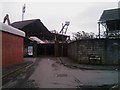
Demolition of The Vetch Field football ground
Redevelopment work has finally started on the Vetch, the home of football in Swansea from its opening in 1912 to its closure in 2005 when football activity moved to the Liberty stadium. Today, the grandstands that once resounded to cheers are now succumbing to the grinding and banging of the demolishing machines.
Image: © Hywel Williams
Taken: 22 Feb 2011
0.03 miles
2
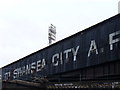
Time's Up!
Swansea City's former ground, Vetch Field, still awaits redevelopment in 2009.
Image: © Colin Smith
Taken: 21 Jul 2009
0.03 miles
3

Part of North Bank, Vetch Field
Football ground after closure, before redevelopment.
Image: © David Lewis
Taken: 25 Feb 2008
0.04 miles
4
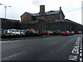
HMP Swansea from the back
The prison was opened in 1861 on a place called Cox's Field.
For the front view on Oystermouth Road see Image]
Image: © Natasha Ceridwen de Chroustchoff
Taken: 21 Oct 2009
0.04 miles
5
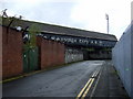
Fallen silent
The derelict grandstand at the Vetch Field, the home of Swansea City since 1912, abandoned in 2005 and replaced by the Liberty Stadium in Landore.
There are plans to develop the site with more shops and a leisure centre but this does not seem to have started yet.
Image: © Natasha Ceridwen de Chroustchoff
Taken: 21 Oct 2009
0.05 miles
6
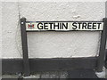
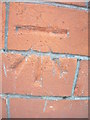
Ordnance Survey Cut Mark
This OS cut mark can be found under the road sign for Gethin Street on No9 Western Street. It marks a point 7.059m above mean sea level.
Image: © Adrian Dust
Taken: 17 Oct 2012
0.06 miles
7
Ordnance Survey Cut Mark
This OS cut mark can be found on the wall of The Singleton Hotel. It marks a point 7.254m above mean sea level.
Image: © Adrian Dust
Taken: 17 Oct 2012
0.06 miles
8
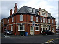
The Singleton Hotel
In Dillwyn Street, not far from the Grand Theatre hence the masks of tragedy and comedy above the main door.
Image: © Natasha Ceridwen de Chroustchoff
Taken: 21 Oct 2009
0.06 miles
9
The Clarence Inn in Clarence Street
Close to the Vetch Field, Swansea City's former home ground, this is one of several pubs whose custom was affected by the football club's move to a new venue in 2005.
Image: © Natasha Ceridwen de Chroustchoff
Taken: 21 Oct 2009
0.07 miles
10
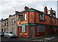
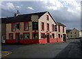
The demise of another pub?
The Garibaldi Inn in Western Street was one of the pubs hit by the closure of the nearby Swansea City AFC's home ground at Vetch Field in 2005. The fans have moved elsewhere and so has trade.
Image: © Natasha Ceridwen de Chroustchoff
Taken: 21 Oct 2009
0.07 miles