IMAGES TAKEN NEAR TO
Oxford Street, SWANSEA, SA1 3JJ
Introduction
This page details the photographs taken nearby to Oxford Street, SA1 3JJ by members of the Geograph project.
The Geograph project started in 2005 with the aim of publishing, organising and preserving representative images for every square kilometre of Great Britain, Ireland and the Isle of Man.

There are currently over 7.5m images from over14,400 individuals and you can help contribute to the project by visiting https://www.geograph.org.uk
Image Map
Images are licensed for reuse under creativecommons.org/licenses/by-sa/2.0
Notes
- Clicking on the map will re-center to the selected point.
- The higher the marker number, the further away the image location is from the centre of the postcode.
Image Listing (106 Images Found)
Images are licensed for reuse under creativecommons.org/licenses/by-sa/2.0
Image
Details
Distance
2
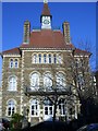
Homegower house
This Grade Two listed building now forms part of a retirement homes complex but was formerly part of the old Swansea General hospital.
Image: © Peter Shaw
Taken: 6 Dec 2008
0.06 miles
3
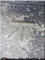
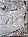
Ordnance Survey Cut Mark
This OS cut mark can be found on the old Hospital Grounds gatepost on St Helen's Road. It marks a point 9.348m above mean sea level.
Image: © Adrian Dust
Taken: 19 Nov 2013
0.06 miles
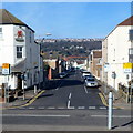
4

Oxford Street, Swansea
A one-way traffic system, away from the camera, and a 20mph speed limit are in force
along this part of Oxford Street, viewed looking SW from the corner of Richardson Street.
Image: © Jaggery
Taken: 27 Apr 2014
0.08 miles
5
Beach Street Swansea
Viewed across Oystermouth Road. Abertawe Alehouse http://www.geograph.org.uk/photo/3677208 is on the left.
Image: © Jaggery
Taken: 26 Feb 2012
0.08 miles
6
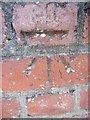
Ordnance Survey Cut Mark
This OS cut mark can be found on the wall next to the phone box on Brunswick Street. It marks a point 12.390m above mean sea level.
Image: © Adrian Dust
Taken: 19 Nov 2013
0.10 miles
8

Ordnance Survey Cut Mark
This OS cut mark can be found on the SE corner of the school on Vincent Street. It marks a point 5.874m above mean sea level.
Image: © Adrian Dust
Taken: 19 Nov 2013
0.10 miles
9
Ordnance Survey Cut Mark
This OS cut mark can be found on the gate post to the customer parking area for 'South Wales Window Blind Centre' on Beach Street.. It marks a point 7.007m above mean sea level.
Image: © Adrian Dust
Taken: 19 Nov 2013
0.10 miles
10
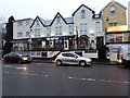
The Wig and Pen
Bar and restaurant on St Helen's Road, Swansea
Image: © Eirian Evans
Taken: 31 Jan 2017
0.12 miles