IMAGES TAKEN NEAR TO
Dynevor Place, SWANSEA, SA1 3ET
Introduction
This page details the photographs taken nearby to Dynevor Place, SA1 3ET by members of the Geograph project.
The Geograph project started in 2005 with the aim of publishing, organising and preserving representative images for every square kilometre of Great Britain, Ireland and the Isle of Man.

There are currently over 7.5m images from over14,400 individuals and you can help contribute to the project by visiting https://www.geograph.org.uk
Image Map
Images are licensed for reuse under creativecommons.org/licenses/by-sa/2.0
Notes
- Clicking on the map will re-center to the selected point.
- The higher the marker number, the further away the image location is from the centre of the postcode.
Image Listing (266 Images Found)
Images are licensed for reuse under creativecommons.org/licenses/by-sa/2.0
Image
Details
Distance
1
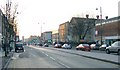
Swansea Kingsway (Recreated)
A view west down the Kingsway from very near the roundabout at the far east end.
The general layout hasn't changed too much since this 1965 photo from the Frith collection: http://www.francisfrith.com/search/wales/west+glamorgan/swansea/photos/swansea_S240206.htm
Image: © Nigel Davies
Taken: 28 Dec 2006
0.01 miles
2
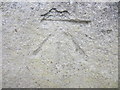
Ordnance Survey Cut Mark
This Ordnance Survey Cut Mark can be found on the NE Face of Mount Pleasant Chapel. It marks a point 13.7129m above mean sea level.
Image: © Adrian Dust
Taken: 18 Jun 2013
0.02 miles
3
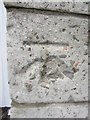
Ordnance Survey Cut Mark
This damaged OS cut mark can be found on the front of NO37 The Kingsway. The building was the HM Land Registry but is now the Chinese Community Co-op. It marks a point 13.061m above mean sea level.
Image: © Adrian Dust
Taken: 22 Oct 2013
0.03 miles
4
Swansea Magistrates Court
Viewed across the A4118 Grove Place from the pavement outside Swansea Central police station.
Image: © Jaggery
Taken: 6 Dec 2013
0.03 miles
5
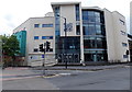
Dynevor Centre, Swansea
Dynevor Centre For Art Design & Media in De La Beche Street is part of Swansea Metropolitan University Faculty of Art & Design. Behind the lamppost, the giant QR code image is a recent addition.
Image: © Jaggery
Taken: 27 Apr 2014
0.03 miles
6
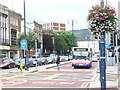
Kingsway
Busy post-WW2 dual carriageway in central Swansea, lined with many post-war buildings.
http://www.swansea.gov.uk/
Image: © Colin Smith
Taken: 21 Jul 2009
0.05 miles
7
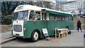
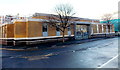
Swansea
Old former George's Coaches of Swansea on display for St David's day
Image: © Colin Prosser
Taken: 29 Feb 2020
0.05 miles
8
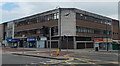
Morris Buildings, Swansea
On the corner of Kingsway and Portland Street, Morris Buildings were officially opened in 1956.
Image: © Jaggery
Taken: 27 Apr 2014
0.05 miles
9
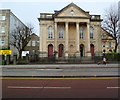
Grade II (star) listed Mount Pleasant Baptist Church, Swansea
Church in the Classical style, located on The Kingsway. Built in 1825, enlarged in 1876 with some later modifications and additions. Grade II (star) listed in 1987.
Image: © Jaggery
Taken: 11 Mar 2012
0.05 miles
10
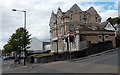
Druslyn House, Swansea
Offices on the corner of Mount Pleasant and De La Beche Street.
A Tesco Express is in the background, in De La Beche Street.
Image: © Jaggery
Taken: 27 Apr 2014
0.06 miles