IMAGES TAKEN NEAR TO
SA1 2TF
Introduction
This page details the photographs taken nearby to SA1 2TF by members of the Geograph project.
The Geograph project started in 2005 with the aim of publishing, organising and preserving representative images for every square kilometre of Great Britain, Ireland and the Isle of Man.

There are currently over 7.5m images from over14,400 individuals and you can help contribute to the project by visiting https://www.geograph.org.uk
Image Map
Images are licensed for reuse under creativecommons.org/licenses/by-sa/2.0
Notes
- Clicking on the map will re-center to the selected point.
- The higher the marker number, the further away the image location is from the centre of the postcode.
Image Listing (4 Images Found)
Images are licensed for reuse under creativecommons.org/licenses/by-sa/2.0
Image
Details
Distance
1
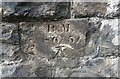
Benchmark on Railway Bridge
This tiny Benchmark can be found on the SW buttress of the railway bridge on Nantong Way.
Image: © Adrian Dust
Taken: 21 Sep 2021
0.14 miles
2
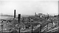
Scene of industrial decay in Landore Valley, Swansea
View NE, towards Morriston and Llansamlet, taken from an Up train on the South Wales main line near Landore. Over to the left is the River Tawe. [This was not an easy location to pin-point, so is open to correction, but note the milepost 213.III and the abandoned railway track underneath, which I believe had been a loop, part of the separate ex-Midland Railway complex.]
Image: © Ben Brooksbank
Taken: 13 Apr 1962
0.18 miles
4
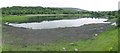
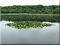
The Pluck
Just across the road from Morrisons and the old dry ski slope lies this lake. There are paths around it and it is near community woodland.
The lake is rumoured to be home to a crocodile or alligator "The Pluck Ness Monster" (!!) but judging by the ducks that are always on it, I doubt that.
Image: © Nigel Davies
Taken: 24 Jul 2010
0.25 miles