IMAGES TAKEN NEAR TO
Field Street, SWANSEA, SA1 2JZ
Introduction
This page details the photographs taken nearby to Field Street, SA1 2JZ by members of the Geograph project.
The Geograph project started in 2005 with the aim of publishing, organising and preserving representative images for every square kilometre of Great Britain, Ireland and the Isle of Man.

There are currently over 7.5m images from over14,400 individuals and you can help contribute to the project by visiting https://www.geograph.org.uk
Image Map
Images are licensed for reuse under creativecommons.org/licenses/by-sa/2.0
Notes
- Clicking on the map will re-center to the selected point.
- The higher the marker number, the further away the image location is from the centre of the postcode.
Image Listing (120 Images Found)
Images are licensed for reuse under creativecommons.org/licenses/by-sa/2.0
Image
Details
Distance
1
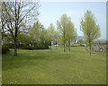
Morfa Copper Works (site of Swansea Canal and Mile End Cottages)
This 1998 view was taken from the green just to the west of the former Morfa Copper Works site. Swansea Canal ran along the right hand wall until it was completely filled during the 1970s. The Morriston branch line used to run on a viaduct which would have crossed this area - this was demolished in the 1970s.
Mile End Cottages would have stood to the left of this view until the 1960s.
Morfa was operated by Williams Foster & Co. from 1835-80. Between 1880 - 93 it was operated by Williams Foster & Co. and between 1893 - 1924 by Williams Foster & Co. Ltd and Pascoe Grenfell & Co. Ltd. Hafod Copper Works was taken over by Morfa in 1924. British Copper Manufacturers owned the combined works until 1928, when they were taken over by ICI, although the refining of copper had ended around 1924.
The site was taken over by Yorkshire Imperial Metals, an amalgamation of ICI and Yorkshire Metals in 1957, the two works worked as one until closure in August 1980.
The grainy image quality was due to the use of an early digital camera (Fuji MX700)
Image: © vectorkraft
Taken: 8 May 1998
0.06 miles
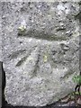
2
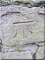
Ordnance Survey Cut Mark
This OS cut mark can be found on the wall to the north of Station Road. It marks a point 22.918m above mean sea level.
Image: © Adrian Dust
Taken: 10 Jan 2014
0.06 miles
3
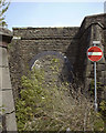
Former Landore High Level (GWR) Station Entrance
This 1998 image taken from the junction of Hamilton Street and Station Road shows the bricked up entrance to the former Landore High Level (GWR) Station which closed in November 1964.
This station was suffixed 'High Level' for a while to distinguish it from the 'Low Level' station which closed in 1954.
Another bricked up arch exists further down Station Road.
Image: © vectorkraft
Taken: 8 May 1998
0.07 miles
4
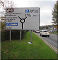
Directions sign alongside the A4067, Swansea
Facing southbound traffic on the A4067. The brown part of the sign is for the Liberty Stadium.
Image: © Jaggery
Taken: 20 Oct 2018
0.07 miles
5
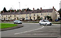
Row of houses on the west side of Neath Road, Swansea
Viewed across the B4603 from the A4067.
Image: © Jaggery
Taken: 20 Oct 2018
0.07 miles
6
Ordnance Survey Cut Mark
This OS cut mark can be found at the entrance to the Station Road subway. It marks a point 24.655m above mean sea level.
Image: © Adrian Dust
Taken: 10 Jan 2014
0.08 miles
7
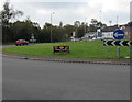
Denny's advert on a Swansea roundabout
The advert for Denny's, the Home of Pancakes, is on the roundabout
in the middle of the junctions of the A4067, A4217 and B4603.
Image: © Jaggery
Taken: 20 Oct 2018
0.08 miles
8
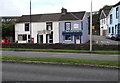
The Azads Tandoori House, 218 Neath Road, Swansea
Takeaway on the corner of Station Road opposite the Liberty Stadium.
Image: © Jaggery
Taken: 20 Oct 2018
0.09 miles
9
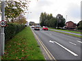
A4067 40mph speed limit past the Liberty Stadium, Swansea
The speed limit sign alongside the A4067 is on a lamppost near a hedge at the western edge of the Liberty Stadium.
Image: © Jaggery
Taken: 20 Oct 2018
0.09 miles
10
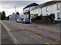
South along Neath Road, Swansea
The B4603 Neath Road approaches the right turn for Station Road, behind the parked cars.
Image: © Jaggery
Taken: 20 Oct 2018
0.10 miles