IMAGES TAKEN NEAR TO
Neath Road, SWANSEA, SA1 2HL
Introduction
This page details the photographs taken nearby to Neath Road, SA1 2HL by members of the Geograph project.
The Geograph project started in 2005 with the aim of publishing, organising and preserving representative images for every square kilometre of Great Britain, Ireland and the Isle of Man.

There are currently over 7.5m images from over14,400 individuals and you can help contribute to the project by visiting https://www.geograph.org.uk
Image Map
Images are licensed for reuse under creativecommons.org/licenses/by-sa/2.0
Notes
- Clicking on the map will re-center to the selected point.
- The higher the marker number, the further away the image location is from the centre of the postcode.
Image Listing (122 Images Found)
Images are licensed for reuse under creativecommons.org/licenses/by-sa/2.0
Image
Details
Distance
1
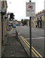
CLEAN IT UP notice, Neath Road, Hafod, Swansea
The City and County of Swansea notice states that this area
is designated under the Dogs (Fouling of Land) Act 1996.
The maximum penalty for not cleaning up your dog's droppings is £1,000.
The text is also in Welsh.
Image: © Jaggery
Taken: 25 Oct 2018
0.01 miles
2
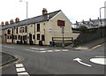
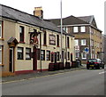
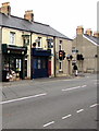
Smiths Arms, Hafod, Swansea
Pub at 51-52 Neath Road in the Hafod area of Swansea.
The mini-roundabout is at the Neath Road/Morgan Street intersection.
Image: © Jaggery
Taken: 25 Oct 2018
0.01 miles
3
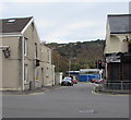
Junction of Neath Road and Maliphant Street, Swansea
Maliphant Street descends from the B4603 Neath Road.
Image: © Jaggery
Taken: 25 Oct 2018
0.02 miles
4
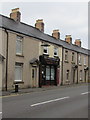
Property Management Rentals office in Hafod, Swansea
Office at 47 Neath Road in the Hafod area of Swansea.
Image: © Jaggery
Taken: 25 Oct 2018
0.02 miles
5
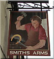
Smiths Arms name sign, Hafod, Swansea
Hanging from a wall bracket here. https://www.geograph.org.uk/photo/5953886
Image: © Jaggery
Taken: 25 Oct 2018
0.02 miles
6
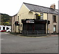
Former Coppermill Cafe in Swansea
In October 2018 a To Let board is on the wall of the shuttered
former cafe at 1376A Neath Road on the corner of Maliphant Street.
Image: © Jaggery
Taken: 25 Oct 2018
0.02 miles
7
Smiths Arms, Hafod, Swansea
Pub at 51-52 Neath Road. https://www.geograph.org.uk/photo/5953889 to the name sign.
Image: © Jaggery
Taken: 25 Oct 2018
0.03 miles
8
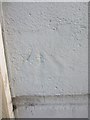
Ordnance Survey Cut Mark
This OS cut mark, heavily painted over, can be found on the Hafod Inn. It marks a point 23.236m above mean sea level.
Image: © Adrian Dust
Taken: 11 Dec 2013
0.03 miles
9
Kevin Thomas Pharmacy, Hafod, Swansea
On the left at 40 Neath Road in the Hafod area of Swansea.
The walker is on the corner of Monger Street.
Image: © Jaggery
Taken: 25 Oct 2018
0.03 miles
10
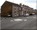
Mini-roundabout at an intersection in Hafod, Swansea
In the middle of the intersection of the B4603 Neath Road and Morgan Street in the Hafod area of Swansea.
Image: © Jaggery
Taken: 25 Oct 2018
0.04 miles