IMAGES TAKEN NEAR TO
Vernon Street, SWANSEA, SA1 2EZ
Introduction
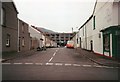
This page details the photographs taken nearby to Vernon Street, SA1 2EZ by members of the Geograph project.
The Geograph project started in 2005 with the aim of publishing, organising and preserving representative images for every square kilometre of Great Britain, Ireland and the Isle of Man.

There are currently over 7.5m images from over14,400 individuals and you can help contribute to the project by visiting https://www.geograph.org.uk
Image Map
Images are licensed for reuse under creativecommons.org/licenses/by-sa/2.0
Notes
- Clicking on the map will re-center to the selected point.
- The higher the marker number, the further away the image location is from the centre of the postcode.
Image Listing (156 Images Found)
Images are licensed for reuse under creativecommons.org/licenses/by-sa/2.0
Image
Details
Distance
1
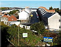
Hafod Street, Swansea
Viewed across the A483 from Bethesda Street. There is a roofless building on the left.
Image: © Jaggery
Taken: 10 Nov 2013
0.02 miles
2
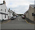
Villiers Street, Swansea
Dead-end street on the east side of Neath Road.
The Villiers Arms pub https://www.geograph.org.uk/photo/5953792 is on the left.
Image: © Jaggery
Taken: 25 Oct 2018
0.03 miles
3

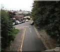
Cwm Terrace, Swansea
From Neath Road, Cwm Terrace leads to Vernon Street and Upper Strand.
Image: © Jaggery
Taken: 25 Oct 2018
0.05 miles
4
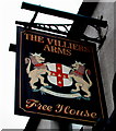
Villiers Arms name sign, Swansea
Hanging from a wall bracket here. https://www.geograph.org.uk/photo/5953792
Image: © Jaggery
Taken: 25 Oct 2018
0.05 miles
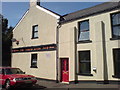
5
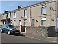
Nos 17 to 20 Villiers Street
Thomas John Fox of number 20 married Elizabeth Davies of number 18 at St John's Church in 1903.
Image: © Deborah Tilley
Taken: 26 Jul 2008
0.05 miles
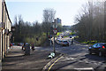
6
Towards Upper Strand, Swansea
Viewed from the south side of the B4603 Bridge Street looking towards houses in Upper Strand.
Image: © Jaggery
Taken: 25 Oct 2018
0.06 miles
7
Bridge Street, Swansea
Seen here taking over from Neath Road which peters out to the left. This is on the edge of the city centre.
Image: © Bill Boaden
Taken: 5 Apr 2016
0.06 miles
8
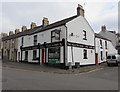
Villiers Arms, Swansea
Pub at 1410 Neath Road on the corner of Villiers Street. https://www.geograph.org.uk/photo/5953797 to the name sign.
Image: © Jaggery
Taken: 25 Oct 2018
0.07 miles
10
Railway warehouse in Hafod
This was demolished in 1994 I think. I remember watching it being demolished in my grandparents house in Earl Street. It was near the railway line visible from Jersey Street.
Image: © J WILLIAMS
Taken: Unknown
0.07 miles