IMAGES TAKEN NEAR TO
Thomas Row, SWANSEA, SA1 1NJ
Introduction
This page details the photographs taken nearby to Thomas Row, SA1 1NJ by members of the Geograph project.
The Geograph project started in 2005 with the aim of publishing, organising and preserving representative images for every square kilometre of Great Britain, Ireland and the Isle of Man.

There are currently over 7.5m images from over14,400 individuals and you can help contribute to the project by visiting https://www.geograph.org.uk
Image Map
Images are licensed for reuse under creativecommons.org/licenses/by-sa/2.0
Notes
- Clicking on the map will re-center to the selected point.
- The higher the marker number, the further away the image location is from the centre of the postcode.
Image Listing (258 Images Found)
Images are licensed for reuse under creativecommons.org/licenses/by-sa/2.0
Image
Details
Distance
1
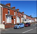
Row of brick houses, Prince of Wales Road, Swansea
On the west side of the road between Bethesda Street and Thomas Row.
Image: © Jaggery
Taken: 19 Apr 2018
0.02 miles
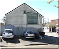
2
The Old Duke, Swansea
Pub at 140 High Street, on the corner of Chapel Street.
http://www.geograph.org.uk/photo/3738063 to a closeup of the name sign.
Image: © Jaggery
Taken: 10 Nov 2013
0.02 miles
3
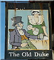
The Old Duke name sign, Swansea
Hanging from a wall bracket here. http://www.geograph.org.uk/photo/3738058
Image: © Jaggery
Taken: 10 Nov 2013
0.02 miles
4
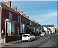
Prince of Wales Road houses, Swansea
Viewed looking north towards Thomas Row.
Image: © Jaggery
Taken: 10 Nov 2013
0.02 miles
5
Old Duke name sign, Swansea
On the north side of this pub https://www.geograph.org.uk/photo/3738058 at 140 High Street.
Image: © Jaggery
Taken: 19 Apr 2018
0.02 miles
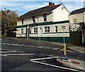
6
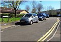
On-street parking, Chapel Street, Swansea
Viewed from the corner of Greenhill Street. Dyfatty & Greenhill Community Centre https://www.geograph.org.uk/photo/5744596 is on the left.
Image: © Jaggery
Taken: 19 Apr 2018
0.03 miles
7
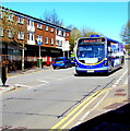
X13 bus, High Street, Swansea
The First bus on route X13 from Llandeilo via Ammanford and Pontarddulais heads south along High Street towards the route's terminus at Swansea City Bus Station about 2km behind the camera. Currently showing the Welsh Abertawe, the electronic display will change to show Swansea in a second or two.
Image: © Jaggery
Taken: 19 Apr 2018
0.03 miles
8
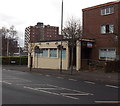
Former Lamb pub in High Street, Swansea
At the early December 2013 date of this view, there was an estate agent board on the building
that used to be The Lamb pub, on the corner of High Street and Croft Street.
Image: © Jaggery
Taken: 6 Dec 2013
0.03 miles
9
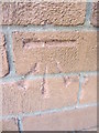
Ordnance Survey Cut Mark
This OS cut mark can be found on the Lower Lamb PH. It marks a point 26.731m above mean sea level.
Image: © Adrian Dust
Taken: 11 Dec 2013
0.03 miles
10
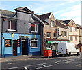
The Full Moon, Swansea
The pub at 144 High Street is next door to TSA Continental Supermarket, formerly Wah Yu Chinese Supermarket.
Image: © Jaggery
Taken: 10 Nov 2013
0.03 miles