IMAGES TAKEN NEAR TO
Tontine Street, SWANSEA, SA1 1NA
Introduction
This page details the photographs taken nearby to Tontine Street, SA1 1NA by members of the Geograph project.
The Geograph project started in 2005 with the aim of publishing, organising and preserving representative images for every square kilometre of Great Britain, Ireland and the Isle of Man.

There are currently over 7.5m images from over14,400 individuals and you can help contribute to the project by visiting https://www.geograph.org.uk
Image Map
Images are licensed for reuse under creativecommons.org/licenses/by-sa/2.0
Notes
- Clicking on the map will re-center to the selected point.
- The higher the marker number, the further away the image location is from the centre of the postcode.
Image Listing (294 Images Found)
Images are licensed for reuse under creativecommons.org/licenses/by-sa/2.0
Image
Details
Distance
1
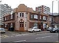
The White Swan, Swansea
High Street pub on the corner of Swan Street.
Update. Here's http://www.geograph.org.uk/photo/3737917 how the pub looked in November 2013.
Image: © Jaggery
Taken: 26 Feb 2012
0.02 miles
2
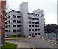
Ty Bryn Glas, Swansea
Ty Bryn Glas is a modern purpose-built 6-storey office block, viewed along Powell Street from the edge of High Street.
Image: © Jaggery
Taken: 26 Feb 2012
0.02 miles
3
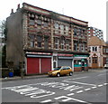
Three High Street shops, Swansea
From left to right are:
Ghazi Food & Veg Store, 83 High Street.
Lulu Beauty Shop, 84 High Street.
Tariq Food Store, 85 High Street.
Image: © Jaggery
Taken: 26 Feb 2012
0.02 miles
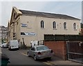
4
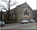
St Matthew's Church, Swansea
High Street church located between Tontine Street and Swan Street. The church is owned by the Church in Wales but its major user since 2010 has been the Swansea Community of St Zachariah and St Elizabeth, a part of the Holy Apostolic Orthodox Catholic Church, sometimes called the Eastern Orthodox Church.
Image: © Jaggery
Taken: 26 Feb 2012
0.02 miles
5
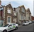
Ebenezer Baptist Church, Swansea
Viewed across Ebenezer Street from the New Orchard Street end.
Image: © Jaggery
Taken: 25 Sep 2013
0.03 miles
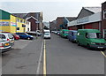
6
Tontine Street Swansea
Viewed from the A4118 end looking east towards High Street.
Image: © Jaggery
Taken: 25 Sep 2013
0.03 miles
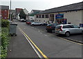
7
Ebenezer Street, Swansea
Looking east towards High Street from the New Orchard Street end.
Ebenezer Baptist Church http://www.geograph.org.uk/photo/3669493 is on the left in the middle distance.
Image: © Jaggery
Taken: 25 Sep 2013
0.03 miles
8
East side of Ebenezer Baptist Church, Swansea
Viewed along Ebenezer Street from the High Street end.
Image: © Jaggery
Taken: 25 Sep 2013
0.03 miles
9
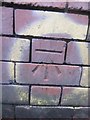
Ordnance Survey Cut Mark
This OS cut mark can be found on the Nisa building to the south of Ebenezer Street. It marks a point 20.592m above mean sea level.
Image: © Adrian Dust
Taken: 25 Oct 2013
0.03 miles
10
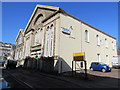
Grade II (star) Listed Ebenezer Baptist Church, Ebenezer Street, Swansea
Formerly the Ebenezer Chapel of the Welsh Independents, the building dates from 1862.
The blue plaque https://www.geograph.org.uk/photo/5709753 on the building records that the Reverend Dr Griffith John (1831-1912),
pioneer missionary in Hankow, China, worshipped and was ordained here.
Image: © Jaggery
Taken: 16 Mar 2018
0.03 miles