IMAGES TAKEN NEAR TO
Coed-y-Rhaidyr, NEATH, SA11 5NU
Introduction
This page details the photographs taken nearby to Coed-y-Rhaidyr, SA11 5NU by members of the Geograph project.
The Geograph project started in 2005 with the aim of publishing, organising and preserving representative images for every square kilometre of Great Britain, Ireland and the Isle of Man.

There are currently over 7.5m images from over14,400 individuals and you can help contribute to the project by visiting https://www.geograph.org.uk
Image Map (Loading...)


Getting Data...Please wait
Leaflet Map data © OpenStreetMap
Images are licensed for reuse under creativecommons.org/licenses/by-sa/2.0
Notes
- Clicking on the map will re-center to the selected point.
- The higher the marker number, the further away the image location is from the centre of the postcode.
Image Listing (35 Images Found)
Images are licensed for reuse under creativecommons.org/licenses/by-sa/2.0
Image
Details
Distance
1
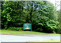
Brecon Beacons National Park directions, Pontneddfechan
The large sign is located at the eastern edge of Pontneddfechan, near the village hall. http://www.geograph.org.uk/photo/3104158
Go left for the Old Gunpowder Works. Go right for Dinas Rock.
Image: © Jaggery
Taken: 7 Aug 2011
0.03 miles
3
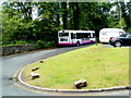
First bus waits in the Min-yr-awel turning circle, Pontneddfechan
This is the Min-yr-awel Pontneddfechan terminus for First service X5 from Neath.
The hourly Sunday service is scheduled to arrive here at 10 minutes to the hour and depart 15 minutes later. The journey to or from Neath takes about 45 minutes.
The X5 serves Pontneddfechan on Sundays only. On other days, the terminus is at Pontwalby Bridge at the eastern edge of Glynneath, and most X5 buses start from and end at Swansea.
Image: © Jaggery
Taken: 7 Aug 2011
0.03 miles
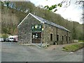
4
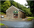
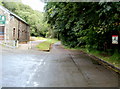
Pontneddfechan Village Hall
Located at the eastern edge of village at the far end of Dinas Road, about a kilometre from High Street.
Image: © Jaggery
Taken: 7 Aug 2011
0.04 miles
5
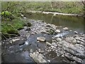
Confluence of the Sychryd and the Mellte
The Sychryd upstream somehow looks far more significant than the small dribble joining the Mellte here.
Image: © Nigel Davies
Taken: 15 Apr 2012
0.05 miles
6
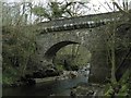
Road bridge over river Mellte
This is the very narrow bridge at the end of Dinas road that allows access to the car park. The view is from slightly downstream near the confluence with the Sychryd
Image: © Nigel Davies
Taken: 15 Apr 2012
0.05 miles
7

Bridge over the end of the Sychryd
This is the very final stretch of the Sychryd before it joins the Mellte. The bridge in the background leads to Pen-cae-drain.
Image: © Nigel Davies
Taken: 15 Apr 2012
0.07 miles
8
Narrow road east of the village hall, Pontneddfechan
On passing the village hall, http://www.geograph.org.uk/photo/3104158 the road ahead narrows to a single-track lane.
Image: © Jaggery
Taken: 7 Aug 2011
0.07 miles
9
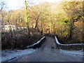
Pont Mellte Bridge
Pont yn rhychwantu Afon Mellte. Cyn i'r heol gael ei rhannu'n ddwy gan ddeuffordd yr A465 yr oedd y ffordd ar un adeg yn cysylltu pentre Pontneddechan a Chefn Rhigos.
A bridge spanning the Mellte River (trans. like lightning). Before being bisected by the A465 dual carriageway this lane formerly connected Pontneddfechan (trans. lesser Neath river bridge) with the village of Cefn Rhigos (trans. ridge of abundant heather).
Image: © Alan Richards
Taken: 29 Dec 2014
0.07 miles
10
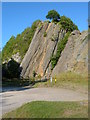
Craig-Y-Ddinas
Craig-Y-Ddinas or the Dinas Rock. There was a mine on the site providing silica for fire bricks.
Image: © Kevin Trahar
Taken: 17 Jul 2005
0.08 miles