IMAGES TAKEN NEAR TO
Glan Gwrelych, NEATH, SA11 5LN

Introduction

This page details the photographs taken nearby to Glan Gwrelych, SA11 5LN by members of the Geograph project.

The Geograph project started in 2005 with the aim of publishing, organising and preserving representative images for every square kilometre of Great Britain, Ireland and the Isle of Man.

There are currently over 7.5m images from over14,400 individuals and you can help contribute to the project by visiting https://www.geograph.org.uk

Image Map


Images are licensed for reuse under creativecommons.org/licenses/by-sa/2.0
Notes
  • Clicking on the map will re-center to the selected point.
  • The higher the marker number, the further away the image location is from the centre of the postcode.

Image Listing (33 Images Found)

Images are licensed for reuse under creativecommons.org/licenses/by-sa/2.0
  • ...
Image
Details
Distance
1
Glan Gwrelych, Pont-Walby
Image: © Alex McGregor Taken: 16 Jun 2011
0.04 miles
2
Ivorites Row, Pont Walby
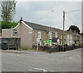
Houses viewed from Merthyr Road. Ivorites Row leads to Glan Gwrelych, a roughly triangular area of houses.
Image: © Jaggery Taken: 26 May 2010
0.08 miles
3
Merthyr Road, Pont Walby
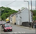
Merthyr Road heads away southeast from Pont Walby bridge across the River Neath.
Image: © Jaggery Taken: 26 May 2010
0.08 miles
4
Disused railway line near Pont Walby
This is part of the disused railway line near Pont Walby which has been turned into a walk by the local council.
Image: © Helen Taken: 16 May 2015
0.10 miles
5
A465 river bridge, Glynneath
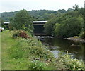
Viewed from a track on the north bank of the River Neath.
Image: © Jaggery Taken: 31 Jul 2011
0.10 miles
6
Aberdare Road, Glynneath
Houses on the north side of the road. In the distance, tucked in between a gap in the houses, is the Methodist Church. http://www.geograph.org.uk/photo/2585741
Image: © Jaggery Taken: 4 Sep 2011
0.11 miles
7
A465 bridge over Aberdare Road, Glynneath
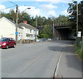
A few metres beyond the left turn for Ynyslas Crescent, http://www.geograph.org.uk/photo/1882394 Aberdare Road passes under the A465.
Image: © Jaggery Taken: 4 Sep 2011
0.11 miles
8
Methodist Church, Glynneath
Located on Aberdare Road. The foundation stone was laid in 1890. On completion of the building work, it was dedicated for worship in 1892 as the Wesleyan Chapel.
Image: © Jaggery Taken: 4 Sep 2011
0.11 miles
9
River Neath and A465 road bridge near Glyn-neath
View looks westwards along the River Neath with the road bridge carrying the A465 in the background.
Image: © Roger Davies Taken: 8 Aug 2008
0.12 miles
10
Brunel's rail viaduct near Pont Walby
The old railway that connected the mines up along the Vale of Neath has been dismantled. Much of it has disappeared beneath the A465 "Heads of the Valleys" road. Not all parts of the railway were used and this old viaduct over Nant Gwrelych has survived. It now forms part of a farm track. See also Image
Image: © Nigel Davies Taken: 26 May 2013
0.12 miles
  • ...