IMAGES TAKEN NEAR TO
Glynneath, NEATH, SA11 5EW
Introduction
This page details the photographs taken nearby to SA11 5EW by members of the Geograph project.
The Geograph project started in 2005 with the aim of publishing, organising and preserving representative images for every square kilometre of Great Britain, Ireland and the Isle of Man.

There are currently over 7.5m images from over14,400 individuals and you can help contribute to the project by visiting https://www.geograph.org.uk
Image Map
Images are licensed for reuse under creativecommons.org/licenses/by-sa/2.0
Notes
- Clicking on the map will re-center to the selected point.
- The higher the marker number, the further away the image location is from the centre of the postcode.
Image Listing (29 Images Found)
Images are licensed for reuse under creativecommons.org/licenses/by-sa/2.0
Image
Details
Distance
1
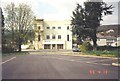
Glynneath miners welfare hall
This Welfare hall had a good snooker room & library on the ground floor & a cinema on the upper floors.
Image: © Alwyn Martin
Taken: 13 Apr 1993
0.03 miles
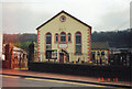
3
Addoldy Chapel, Glynneath
The Chapel where I was married
Image: © Alwyn Martin
Taken: Unknown
0.03 miles
4
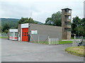
Glynneath Fire Station and tower
Located on the north side of Park Avenue, next to the Ambulance Station. http://www.geograph.org.uk/photo/2578460
The Fire Station is part of the Neath & Port Talbot County Command within the Mid and West Wales Fire and Rescue Service.
Image: © Jaggery
Taken: 31 Jul 2011
0.03 miles
5
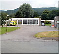
Glynneath Ambulance Station
Located on the north side of Park Avenue. The fire station http://www.geograph.org.uk/photo/2578477 is on the right.
Image: © Jaggery
Taken: 31 Jul 2011
0.03 miles
6
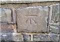
Ordnance Survey Cut Mark
This OS cut mark can be found on the SE parapet of the bridge. It marks a point 53.598m above mean sea level.
Image: © Adrian Dust
Taken: 13 Sep 2017
0.05 miles
7
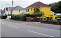
Mellow yellow, Glynneath
Yellow detached house on the corner of Park Avenue (B4242) and Lon-y-parc.
Image: © Jaggery
Taken: 31 Jul 2011
0.07 miles
8
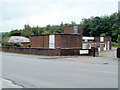
BT telephone exchange, Glynneath
Located on Park Avenue (B4242) opposite an Esso filling station and Tesco Express. http://www.geograph.org.uk/photo/2578485
Telephone exchanges are not designed to win architectural awards, but many seem to be unattractive, forbidding places, such as this one. Perhaps they are intentionally designed like that...
Image: © Jaggery
Taken: 31 Jul 2011
0.07 miles
9
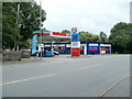
Esso filling station and Tesco Express, Glynneath
Located on the north side of Park Avenue (B4242). Open from 6am to midnight.
Image: © Jaggery
Taken: 31 Jul 2011
0.07 miles
10
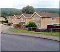
Roberts Close, Glynneath
Roberts Close is a short cul-de-sac on the north side of B4242, between the Lamb and Flag http://www.geograph.org.uk/photo/2578421 to the west and the ambulance station and fire station to the east.
Faintly visible on the hilltops are wind turbines.
Image: © Jaggery
Taken: 31 Jul 2011
0.07 miles