IMAGES TAKEN NEAR TO
St. Cadocs, Aberdare Road, NEATH, SA11 5AQ
Introduction
This page details the photographs taken nearby to St. Cadocs, Aberdare Road, SA11 5AQ by members of the Geograph project.
The Geograph project started in 2005 with the aim of publishing, organising and preserving representative images for every square kilometre of Great Britain, Ireland and the Isle of Man.

There are currently over 7.5m images from over14,400 individuals and you can help contribute to the project by visiting https://www.geograph.org.uk
Image Map (Loading...)


Getting Data...Please wait
Leaflet Map data © OpenStreetMap
Images are licensed for reuse under creativecommons.org/licenses/by-sa/2.0
Notes
- Clicking on the map will re-center to the selected point.
- The higher the marker number, the further away the image location is from the centre of the postcode.
Image Listing (35 Images Found)
Images are licensed for reuse under creativecommons.org/licenses/by-sa/2.0
Image
Details
Distance
1
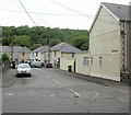
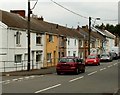
Ynyslas Crescent, Glynneath
Houses on the east side of Ynyslas Crescent, viewed from the corner of Aberdare Road.
Image: © Jaggery
Taken: 26 May 2010
0.02 miles
2
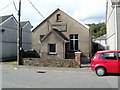
Methodist Church, Glynneath
Located on Aberdare Road. The foundation stone was laid in 1890. On completion of the building work, it was dedicated for worship in 1892 as the Wesleyan Chapel.
Image: © Jaggery
Taken: 4 Sep 2011
0.05 miles
3
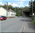
A465 bridge over Aberdare Road, Glynneath
A few metres beyond the left turn for Ynyslas Crescent, http://www.geograph.org.uk/photo/1882394 Aberdare Road passes under the A465.
Image: © Jaggery
Taken: 4 Sep 2011
0.05 miles
4
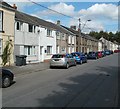
Aberdare Road, Glynneath
Houses on the north side of the road. In the distance, tucked in between a gap in the houses, is the Methodist Church. http://www.geograph.org.uk/photo/2585741
Image: © Jaggery
Taken: 4 Sep 2011
0.05 miles
5
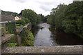
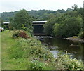
River Neath and A465 road bridge near Glyn-neath
View looks westwards along the River Neath with the road bridge carrying the A465 in the background.
Image: © Roger Davies
Taken: 8 Aug 2008
0.05 miles
6
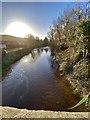
Afon Nedd
The River Neath at Glyn-neath, flowing towards the setting sun.
Image: © Alan Hughes
Taken: 10 Jan 2020
0.06 miles
7
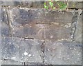
Ordnance Survey Cut Mark
This OS cut mark can be found on the wall NE side of the road. It marks a point 64.826m above mean sea level.
Image: © Adrian Dust
Taken: 19 Jul 2020
0.06 miles
8
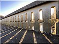
Sunlight pattern
Low sunlight casting shadows through the ‘arrow slits’ on the Afon Nedd bridge at Glyn-neath.
Image: © Alan Hughes
Taken: 10 Jan 2020
0.07 miles
9
A465 river bridge, Glynneath
Viewed from a track on the north bank of the River Neath.
Image: © Jaggery
Taken: 31 Jul 2011
0.07 miles
10
Aberdare Road houses, Glynneath
Houses on the north side of the road viewed from the B4242 junction. http://www.geograph.org.uk/photo/3195970
Image: © Jaggery
Taken: 31 Jul 2011
0.07 miles