IMAGES TAKEN NEAR TO
Tan Y Rhiw Road, NEATH, SA11 4NB
Introduction
This page details the photographs taken nearby to Tan Y Rhiw Road, SA11 4NB by members of the Geograph project.
The Geograph project started in 2005 with the aim of publishing, organising and preserving representative images for every square kilometre of Great Britain, Ireland and the Isle of Man.

There are currently over 7.5m images from over14,400 individuals and you can help contribute to the project by visiting https://www.geograph.org.uk
Image Map (Loading...)


Getting Data...Please wait
Leaflet Map data © OpenStreetMap
Images are licensed for reuse under creativecommons.org/licenses/by-sa/2.0
Notes
- Clicking on the map will re-center to the selected point.
- The higher the marker number, the further away the image location is from the centre of the postcode.
Image Listing (47 Images Found)
Images are licensed for reuse under creativecommons.org/licenses/by-sa/2.0
Image
Details
Distance
1
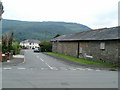
Maes-y-tyra, Resolven
The view from Tan-y-rhiw Road. Maes-y-tyra is residential cul-de-sac. Houses at the far end, out of shot around a bend in the road, border Vaughan Field, http://www.geograph.org.uk/photo/2534104 the home ground of Resolven RFC (rugby football club).
Image: © Jaggery
Taken: 31 Jul 2011
0.01 miles
2
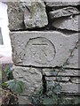
Ordnance Survey Cut Mark
This OS cut mark can be found on a ruined works building to the NE of Maes-Y-Tyra. It marks a point 42.349m above mean sea level.
Image: © Adrian Dust
Taken: 11 Jan 2015
0.04 miles
3
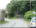
Resolven : road to Glyn Castle
At the eastern edge of Resolven, a road heads into woodland, in the direction of Glyn Castle, a settlement of a few houses in a cleared area of the wood.
Image: © Jaggery
Taken: 31 Jul 2011
0.05 miles
4
Corner of Woodlands Terrace and Pentwyn Road, Resolven
The white detached house is at the NE end of Woodlands Terrace, a cul-de-sac ending at the edge of Nant-y-gleisiad Wood.
Image: © Jaggery
Taken: 31 Jul 2011
0.06 miles
5
Scout hut, Resolven
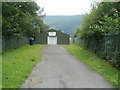
Viewed from Tan-y-rhiw Road, through the perimeter fence. The sign above the doorway shows 12th Neath Resolven Scout Group.
Image: © Jaggery
Taken: 31 Jul 2011
0.06 miles
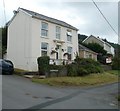
6
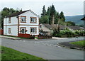
Corner of Tan-y-rhiw Road and Maes-y-tyra, Resolven
A detached house is on the corner of the two roads, near the eastern edge of the village of Resolven.
Image: © Jaggery
Taken: 31 Jul 2011
0.06 miles
7
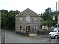
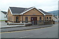
Resolven Community Hall
Located between Tan-y-rhiw Road and Pentwyn Road.
The hall, opened on May 1st 1999, was previously a redundant Salvation Army Hall, and before that, Sion Methodist chapel, built in 1823.
Image: © Jaggery
Taken: 31 Jul 2011
0.06 miles
8
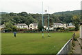
Rugby posts, Vaughan Field, Resolven
The posts, in the club colours, are on Vaughan Field, http://www.geograph.org.uk/photo/2534090 the home ground of Resolven RFC (rugby football club). The houses are on a street named Maes-y-tyra.
Image: © Jaggery
Taken: 31 Jul 2011
0.07 miles
9
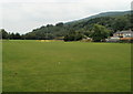
Vaughan Field, Resolven
This is the home ground of Resolven RFC (rugby football club). The club, founded in 1885, played on various grounds in the first few decades. This ground, their home since 1946, was donated by the Vaughan family of Rheola. Previously known as Tan-y-Rhiw Field, the ground was renamed in honour of their benefactors.
Image: © Jaggery
Taken: 31 Jul 2011
0.07 miles
10
Tabernacle Calvinistic Methodist Chapel, Resolven
Located on Tan-y-rhiw Road, on the corner of Lyons Place. Built in 1995.
The nameplate, in Welsh only, above the entrance door shows
TABERNACL Y METHODISTIAID CALFINAIDD 1995.
At the right edge of the view is Resolven War Memorial. http://www.geograph.org.uk/photo/2532210
Image: © Jaggery
Taken: 31 Jul 2011
0.07 miles