IMAGES TAKEN NEAR TO
New Road, NEATH, SA11 4ET
Introduction
This page details the photographs taken nearby to New Road, SA11 4ET by members of the Geograph project.
The Geograph project started in 2005 with the aim of publishing, organising and preserving representative images for every square kilometre of Great Britain, Ireland and the Isle of Man.

There are currently over 7.5m images from over14,400 individuals and you can help contribute to the project by visiting https://www.geograph.org.uk
Image Map (Loading...)


Getting Data...Please wait
Leaflet Map data © OpenStreetMap
Images are licensed for reuse under creativecommons.org/licenses/by-sa/2.0
Notes
- Clicking on the map will re-center to the selected point.
- The higher the marker number, the further away the image location is from the centre of the postcode.
Image Listing (51 Images Found)
Images are licensed for reuse under creativecommons.org/licenses/by-sa/2.0
Image
Details
Distance
1
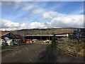
Ynys Nedd Farm
Entrance to Ynys Nedd Farm.
Image: © Alan Hughes
Taken: 21 Feb 2018
0.02 miles
2
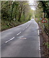
Warning sign - road narrows alongside the B4434 near Clyne
The Clyne boundary sign https://www.geograph.org.uk/photo/6427851 is behind the camera. Ahead for Tonna and Neath.
Image: © Jaggery
Taken: 29 Apr 2016
0.02 miles
3
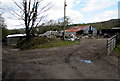
Farm buildings, Clyne
Set back from the B4434 New Road at the southern edge of Clyne.
Image: © Jaggery
Taken: 29 Apr 2016
0.02 miles
4
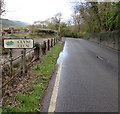
Southern boundary sign, Clyne/Clun
The sign alongside the B4434 New Road shows that Clyne is Clun in Welsh.
Image: © Jaggery
Taken: 29 Apr 2016
0.03 miles
5
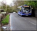
X55 bus for Swansea leaving Clyne
The bus on the B4434 New Road passes the Clyne/Clun boundary sign https://www.geograph.org.uk/photo/6427851 on the left.
Image: © Jaggery
Taken: 29 Apr 2016
0.03 miles
6
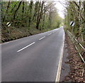
End of the 30 zone south of Clyne
The speed limit on the B4434 increases to the National Speed Limit. Ahead for Tonna and Neath.
Image: © Jaggery
Taken: 29 Apr 2016
0.03 miles
7
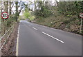
Start of the 30 zone on the approach to Clyne
The National Speed Limit on the B4434 from Tonna drops to 30mph on the approach to Clyne.
The Clyne/Clun boundary sign https://www.geograph.org.uk/photo/6427851 is in the background.
Image: © Jaggery
Taken: 29 Apr 2016
0.03 miles
8
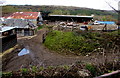
Farm buildings at the southern edge of Clyne
Viewed from the B4434 New Road.
Image: © Jaggery
Taken: 29 Apr 2016
0.04 miles
9
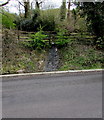
Muddy outfall above the B4434 New Road, Clyne
Water issues from a small-bore pipe above the B4434.
Image: © Jaggery
Taken: 29 Apr 2016
0.06 miles
10
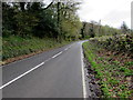
Towards a bend in the B4434, Clyne
This part of the B4434 is named New Road (Heol Newydd in Welsh). https://www.geograph.org.uk/photo/6427841
Image: © Jaggery
Taken: 29 Apr 2016
0.07 miles