IMAGES TAKEN NEAR TO
Bryn Golwg, NEATH, SA11 4EH
Introduction
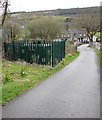
This page details the photographs taken nearby to Bryn Golwg, SA11 4EH by members of the Geograph project.
The Geograph project started in 2005 with the aim of publishing, organising and preserving representative images for every square kilometre of Great Britain, Ireland and the Isle of Man.

There are currently over 7.5m images from over14,400 individuals and you can help contribute to the project by visiting https://www.geograph.org.uk
Image Map
Images are licensed for reuse under creativecommons.org/licenses/by-sa/2.0
Notes
- Clicking on the map will re-center to the selected point.
- The higher the marker number, the further away the image location is from the centre of the postcode.
Image Listing (84 Images Found)
Images are licensed for reuse under creativecommons.org/licenses/by-sa/2.0
Image
Details
Distance
1
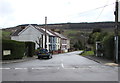
Bryn Golwg, Clyne
Viewed across the B4434. The name sign in a hedge shows that Bryn Golwg leads to Heol Nant and Clyne Terrace.
Image: © Jaggery
Taken: 29 Apr 2016
0.01 miles
2
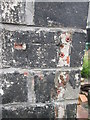
Ordnance Survey Cut Mark
If you look closely you can just make out the OS cut mark on the NW corner of No1 Bryn Colug. It marked a point 33.333m above mean sea level.
Image: © Adrian Dust
Taken: 31 Jul 2014
0.01 miles
3
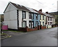
Houses on the east side of Bryn Golwg, Clyne
On the approach to a level crossing.
Image: © Jaggery
Taken: 29 Apr 2016
0.01 miles
4
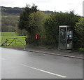
Phonebox and postbox, Bryn Golwg, Clyne
On the right here. https://www.geograph.org.uk/photo/6340991
Image: © Jaggery
Taken: 29 Apr 2016
0.01 miles
5
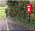
Queen Elizabeth II postbox, Bryn Golwg, Clyne
Located here https://www.geograph.org.uk/photo/6340998 between a postbox and a field gate.
Image: © Jaggery
Taken: 29 Apr 2016
0.01 miles
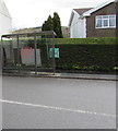
6
Bus shelter detail, Clyne
Located here. https://www.geograph.org.uk/photo/6340504 The Welsh ONI HEUIR NI FEDIR means He who does not sow does not reap.
Image: © Jaggery
Taken: 29 Apr 2016
0.03 miles
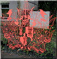
7
Bus shelter on the east side of the B4434, Clyne
A crest or coat of arms https://www.geograph.org.uk/photo/6340510 is depicted on the glass in the middle of the shelter.
Image: © Jaggery
Taken: 29 Apr 2016
0.03 miles
8
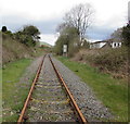
Towards the site of demolished Clyne Halt station
Looking to the northeast from this https://www.geograph.org.uk/photo/6345048 level crossing in April 2016. The rusty single-track line, now freight only, passes the site of Clyne Halt station which closed in 1964.
Image: © Jaggery
Taken: 29 Apr 2016
0.03 miles
9
Gas installation, Clyne
In a locked enclosure on the north side of a level crossing. https://www.geograph.org.uk/photo/6345048
Image: © Jaggery
Taken: 29 Apr 2016
0.03 miles
10
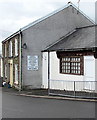
Former shop in Clyne
Viewed across the B4434 in April 2016. The information board on a house side wall shows that the shop sold groceries, confectionery, ice cream, soft drinks, greetings cards, seasonal gifts and was an off licence.
Image: © Jaggery
Taken: 29 Apr 2016
0.03 miles