IMAGES TAKEN NEAR TO
Resolven, NEATH, SA11 4DY
Introduction
This page details the photographs taken nearby to SA11 4DY by members of the Geograph project.
The Geograph project started in 2005 with the aim of publishing, organising and preserving representative images for every square kilometre of Great Britain, Ireland and the Isle of Man.

There are currently over 7.5m images from over14,400 individuals and you can help contribute to the project by visiting https://www.geograph.org.uk
Image Map (Loading...)


Getting Data...Please wait
Leaflet Map data © OpenStreetMap
Images are licensed for reuse under creativecommons.org/licenses/by-sa/2.0
Notes
- Clicking on the map will re-center to the selected point.
- The higher the marker number, the further away the image location is from the centre of the postcode.
Image Listing (7 Images Found)
Images are licensed for reuse under creativecommons.org/licenses/by-sa/2.0
Image
Details
Distance
2
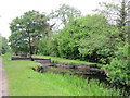
Ynys-yr-Allor Lock
Top end of Ynys-yr-Allor Lock on the Neath Canal.
Image: © David Tyers
Taken: 27 May 2017
0.10 miles
3
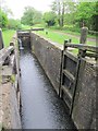
Ynys yr Allor Lock
Ynys yr Allor Lock on the Neath Canal, photographed from the footbridge across the base of the lock.
Image: © David Tyers
Taken: 27 May 2017
0.10 miles
4
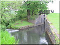
Ynys yr Allor Lock
Lower end of Ynys yr Allor Lock on the Neath Canal, showing the lower lock gates and the bywash rejoining the canal on the left hand side.
Image: © David Tyers
Taken: 27 May 2017
0.11 miles
5
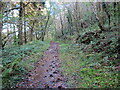
Llwybr ceffyl i Gwmgwrach / Bridleway to Cwmgwrach
Llwybr ceffyl yn mynd drwy'r coed i gyfeiriad Cwmgwrach.
A woodland bridleway heading towards Cwmgwrach (trans. [witch / hag [river] valley).
Image: © Alan Richards
Taken: 10 Oct 2021
0.21 miles
6
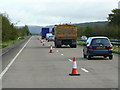
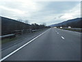
A465 Heads of the Valleys Road
Looking north-east along the Vale of Neath section.
The nearside lane was (conveniently) coned off for surveying work!
Image: © Jonathan Billinger
Taken: 16 Oct 2008
0.21 miles
7
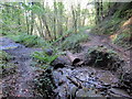
Llwybr ceffyl erydog / Eroded bridleway
Llwybr ceffyl wedi'i erydu gan nant.
A bridleway having been eroded by a stream.
Image: © Alan Richards
Taken: 10 Oct 2021
0.21 miles