IMAGES TAKEN NEAR TO
Clyne, NEATH, SA11 4BW
Introduction
This page details the photographs taken nearby to SA11 4BW by members of the Geograph project.
The Geograph project started in 2005 with the aim of publishing, organising and preserving representative images for every square kilometre of Great Britain, Ireland and the Isle of Man.

There are currently over 7.5m images from over14,400 individuals and you can help contribute to the project by visiting https://www.geograph.org.uk
Image Map (Loading...)


Getting Data...Please wait
Leaflet Map data © OpenStreetMap
Images are licensed for reuse under creativecommons.org/licenses/by-sa/2.0
Notes
- Clicking on the map will re-center to the selected point.
- The higher the marker number, the further away the image location is from the centre of the postcode.
Image Listing (40 Images Found)
Images are licensed for reuse under creativecommons.org/licenses/by-sa/2.0
Image
Details
Distance
1
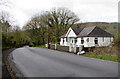
White bungalow in Clyne
On the north side of the B4434 Lletty Dafydd in the village of Clyne (Y Clun in Welsh) in the Vale of Neath.
Image: © Jaggery
Taken: 29 Apr 2016
0.01 miles
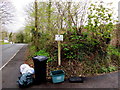
2
Litter bin and speed indicator sign, Clyne
Alongside the B4434 Lletty Dafydd in the village of Clyne (Y Clun in Welsh) in the Vale of Neath.
Image: © Jaggery
Taken: 29 Apr 2016
0.03 miles
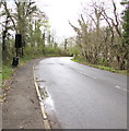
3
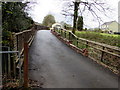
Warning sign - road narrows, Lletty Dafydd, Clyne
Alongside the B4434 Lletty Dafydd on the approach to a narrow bridge over a railway.
Image: © Jaggery
Taken: 29 Apr 2016
0.04 miles
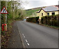
4
This way to Ty Du Farm and a public footpath, Clyne
The farm sign is on a public footpath signpost on the south side of the B4434 Lletty Dafydd.
http://www.geograph.org.uk/photo/5200040 to the farm access road. The public footpath is here. http://www.geograph.org.uk/photo/5200054
Image: © Jaggery
Taken: 29 Apr 2016
0.04 miles
5
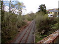
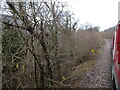
Single-track railway line, Clyne
Viewed from this http://www.geograph.org.uk/photo/5371293 B4434 road bridge in April 2016.
This has been a freight-only line for decades. Clyne Halt station closed in 1964.
Image: © Jaggery
Taken: 29 Apr 2016
0.04 miles
6
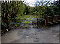
Gate across a public footpath near Ty Du Farm, Clyne
Walkers can used the kissing gate on the right side of the seven-bar gate.
Image: © Jaggery
Taken: 29 Apr 2016
0.05 miles
7
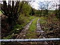
Public footpath near Ty Du Farm, Clyne
Viewed from this http://www.geograph.org.uk/photo/5200051 gate.
Image: © Jaggery
Taken: 29 Apr 2016
0.07 miles
8
Access road to Ty Du Farm, Clyne
From the south side of the B4434 Lletty Dafydd.
Image: © Jaggery
Taken: 29 Apr 2016
0.07 miles
9
View from a charter train - Milepost 37¾
A 2018 rail tour visiting South Wales, mostly freight-only lines. This one is the former Vale of Neath Railway, which is heavily wooded in nature. The milepost is faded but there are three dots underneath the '37' denoting '¾'. It measures 37¾ miles from Pontypool & New Inn station via the Crumlin viaduct and Aberdare - a railway route long since mostly consigned to history.
Image: © Nigel Thompson
Taken: 10 Mar 2018
0.08 miles
10
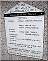
Church information board, Clyne
On the wall of Clyne Free Mission Evangelical Church. http://www.geograph.org.uk/photo/4928316
Image: © Jaggery
Taken: 29 Apr 2016
0.11 miles