IMAGES TAKEN NEAR TO
Maes Pwll, NEATH, SA11 4BT
Introduction
This page details the photographs taken nearby to Maes Pwll, SA11 4BT by members of the Geograph project.
The Geograph project started in 2005 with the aim of publishing, organising and preserving representative images for every square kilometre of Great Britain, Ireland and the Isle of Man.

There are currently over 7.5m images from over14,400 individuals and you can help contribute to the project by visiting https://www.geograph.org.uk
Image Map (Loading...)


Getting Data...Please wait
Leaflet Map data © OpenStreetMap
Images are licensed for reuse under creativecommons.org/licenses/by-sa/2.0
Notes
- Clicking on the map will re-center to the selected point.
- The higher the marker number, the further away the image location is from the centre of the postcode.
Image Listing (95 Images Found)
Images are licensed for reuse under creativecommons.org/licenses/by-sa/2.0
Image
Details
Distance
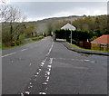
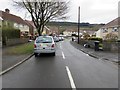
1
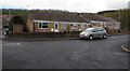
Maes Pwll bungalows, Clyne
Maes Pwll is a cul-de-sac on the south side of the B4434.
Image: © Jaggery
Taken: 29 Apr 2016
0.01 miles
2
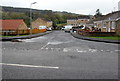
Junction of the B4434 and Maes Pwll, Clyne
From the B4434 towards the cul-de-sac Maes Pwll.
Image: © Jaggery
Taken: 29 Apr 2016
0.01 miles
3
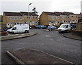
Maes Pwll houses, Clyne
Maes Pwll is a cul-de-sac on the south side of the B4434.
Image: © Jaggery
Taken: 29 Apr 2016
0.03 miles
4
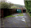
Ynys-yr-Afon waste water pumping station, Clyne
The green cabinet below the B4434 is Welsh Water Asset number 51217.
Image: © Jaggery
Taken: 29 Apr 2016
0.04 miles
5
East along the B4434, Clyne
The B4434, the main road through Clyne, passes the Maes Pwll junction. http://www.geograph.org.uk/photo/5371373
Image: © Jaggery
Taken: 29 Apr 2016
0.05 miles
6
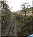
Railway from Clyne towards Neath
Viewed from this http://www.geograph.org.uk/photo/5371296 footbridge.
This has been a freight-only line for decades. Clyne Halt station closed in 1964.
Image: © Jaggery
Taken: 29 Apr 2016
0.05 miles
7
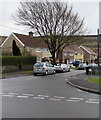
Houses, tree and cars, Ynys yr Afon, Clyne
With a Welsh-only name, Ynys yr Afon is a cul-de-sac on the south side of the B4434.
Image: © Jaggery
Taken: 29 Apr 2016
0.05 miles
8
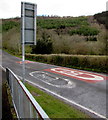
From 20 to 30 on the B4434, Clyne
The 20mph speed limit increases to 30mph.
Image: © Jaggery
Taken: 29 Apr 2016
0.05 miles
9
Ynys yr Afon, Clyne
With a Welsh-only name, Ynys yr Afon is a cul-de-sac on the south side of the B4434 Tonclwyda.
Image: © Jaggery
Taken: 29 Apr 2016
0.05 miles
10
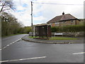
Rusty shelter on a Clyne corner
On the corner of the B4434 and Ynys yr Afon viewed in April 2016.
Image: © Jaggery
Taken: 29 Apr 2016
0.06 miles