IMAGES TAKEN NEAR TO
Ynys Yr Afon, NEATH, SA11 4BP
Introduction
This page details the photographs taken nearby to Ynys Yr Afon, SA11 4BP by members of the Geograph project.
The Geograph project started in 2005 with the aim of publishing, organising and preserving representative images for every square kilometre of Great Britain, Ireland and the Isle of Man.

There are currently over 7.5m images from over14,400 individuals and you can help contribute to the project by visiting https://www.geograph.org.uk
Image Map (Loading...)


Getting Data...Please wait
Leaflet Map data © OpenStreetMap
Images are licensed for reuse under creativecommons.org/licenses/by-sa/2.0
Notes
- Clicking on the map will re-center to the selected point.
- The higher the marker number, the further away the image location is from the centre of the postcode.
Image Listing (96 Images Found)
Images are licensed for reuse under creativecommons.org/licenses/by-sa/2.0
Image
Details
Distance
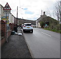
1
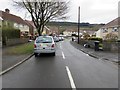
Ynys yr Afon, Clyne
With a Welsh-only name, Ynys yr Afon is a cul-de-sac on the south side of the B4434 Tonclwyda.
Image: © Jaggery
Taken: 29 Apr 2016
0.05 miles
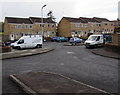
2
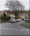
Houses, tree and cars, Ynys yr Afon, Clyne
With a Welsh-only name, Ynys yr Afon is a cul-de-sac on the south side of the B4434.
Image: © Jaggery
Taken: 29 Apr 2016
0.05 miles
3
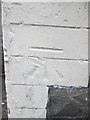
Ordnance Survey Cut Mark
This OS cut mark can be found on No35 Lletty Daffydd. It marks a point 40.770m above mean sea level.
Image: © Adrian Dust
Taken: 31 Jul 2014
0.05 miles
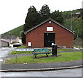
4
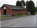
Clyne Community Hall
Alongside the B4434 here named Tonclwyda.
Image: © Jaggery
Taken: 29 Apr 2016
0.05 miles
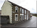
5
Tonclwyda, Clyne
Row of stone houses alongside the B4434.
Image: © Jaggery
Taken: 29 Apr 2016
0.05 miles
6
Ynys yr Afon name sign, Clyne
Facing the B4434 Tonclwyda at the northern end of the cul-de-sac Ynys yr Afon.
The east side of Clyne Community Hall https://www.geograph.org.uk/photo/6340421 is in the background.
Image: © Jaggery
Taken: 29 Apr 2016
0.05 miles
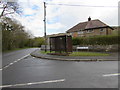
7
Rusty shelter on a Clyne corner
On the corner of the B4434 and Ynys yr Afon viewed in April 2016.
Image: © Jaggery
Taken: 29 Apr 2016
0.06 miles
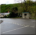
8
Stone bus shelter in Clyne
The shelter alongside the B4434 is opposite the Ynys-yr-Afon junction.
Image: © Jaggery
Taken: 29 Apr 2016
0.07 miles
9
Maes Pwll houses, Clyne
Maes Pwll is a cul-de-sac on the south side of the B4434.
Image: © Jaggery
Taken: 29 Apr 2016
0.07 miles
10
Warning sign - Patrol, Clyne
Facing southbound traffic on the B4434. Behind the sign, Plaid Cymru placards are on display on April 29th 2016 in the week before National Assembly for Wales elections on Thursday May 5th 2016.
Image: © Jaggery
Taken: 29 Apr 2016
0.08 miles