IMAGES TAKEN NEAR TO
Melincourt, NEATH, SA11 4BD
Introduction
This page details the photographs taken nearby to SA11 4BD by members of the Geograph project.
The Geograph project started in 2005 with the aim of publishing, organising and preserving representative images for every square kilometre of Great Britain, Ireland and the Isle of Man.

There are currently over 7.5m images from over14,400 individuals and you can help contribute to the project by visiting https://www.geograph.org.uk
Image Map (Loading...)


Getting Data...Please wait
Leaflet Map data © OpenStreetMap
Images are licensed for reuse under creativecommons.org/licenses/by-sa/2.0
Notes
- Clicking on the map will re-center to the selected point.
- The higher the marker number, the further away the image location is from the centre of the postcode.
Image Listing (12 Images Found)
Images are licensed for reuse under creativecommons.org/licenses/by-sa/2.0
Image
Details
Distance
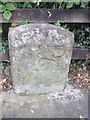
1
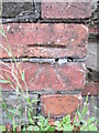
Ordnance Survey Cut Mark
This OS cut mark can be found on the wall of No3 Cored Cottages. It marks a point 42.486m above mean sea level.
Image: © Adrian Dust
Taken: 31 Jul 2014
0.02 miles
2
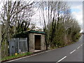
Bus shelter and gas enclosure alongside the B4434, Melincourt
This side of the road for buses to Resolven and Glynneath.
A Wales & West Utilities gas installation is inside the metal enclosure.
Image: © Jaggery
Taken: 29 Apr 2016
0.07 miles
3
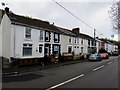
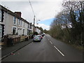
Gored Terrace, Melincourt
Row of houses extending for 80 metres alongside the B4434.
Image: © Jaggery
Taken: 29 Apr 2016
0.09 miles
4
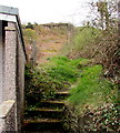
Steps up from the B4434, Melincourt
At the southwest end of Gored Terrace http://www.geograph.org.uk/photo/5199836 steps lead up to a hillside public footpath.
Image: © Jaggery
Taken: 29 Apr 2016
0.10 miles
5
Road from Melincourt towards Clyne
The B4434 passes Gored Terrace. http://www.geograph.org.uk/photo/5199836
Image: © Jaggery
Taken: 29 Apr 2016
0.10 miles
6
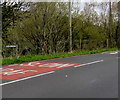
From Clyne to Melincourt
In Neath Port Talbot county borough, the B4434 passes the Melincourt boundary sign which resembles a street name sign. The Clyne boundary sign http://www.geograph.org.uk/photo/5199851 is on the back of this one. Clyne, Melincourt and Resolven make up the electoral ward of Resolven.
Image: © Jaggery
Taken: 29 Apr 2016
0.12 miles
7
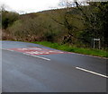
Inconspicuous boundary sign, Clyne
The B4434 from Melincourt passes the small Clyne boundary sign.
The Melincourt sign http://www.geograph.org.uk/photo/5199632 is on the back of this one.
Clyne, Melincourt and Resolven make up the electoral ward of Resolven.
Image: © Jaggery
Taken: 29 Apr 2016
0.12 miles
8
Hillside public footpath, Melincourt
The footpath on the left is accessed via these http://www.geograph.org.uk/photo/5199842 steps up from the B4434.
Image: © Jaggery
Taken: 29 Apr 2016
0.13 miles
9
Mile Stone Resolven 1
This Mile Stone has an Ordnance Survey cut mark in the centre of the front face. It marks a point 34.534m above mean sea level.
Image: © Adrian Dust
Taken: 31 Jul 2014
0.13 miles
10
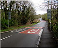
From 20 to 30 on the B4434, Lletty Dafydd, Clyne
Beyond houses and a school, the speed limit increases from 20mph to 30mph.
Image: © Jaggery
Taken: 29 Apr 2016
0.20 miles