IMAGES TAKEN NEAR TO
Cimla Road, NEATH, SA11 3UE
Introduction
This page details the photographs taken nearby to Cimla Road, SA11 3UE by members of the Geograph project.
The Geograph project started in 2005 with the aim of publishing, organising and preserving representative images for every square kilometre of Great Britain, Ireland and the Isle of Man.

There are currently over 7.5m images from over14,400 individuals and you can help contribute to the project by visiting https://www.geograph.org.uk
Image Map (Loading...)


Getting Data...Please wait
Leaflet Map data © OpenStreetMap
Images are licensed for reuse under creativecommons.org/licenses/by-sa/2.0
Notes
- Clicking on the map will re-center to the selected point.
- The higher the marker number, the further away the image location is from the centre of the postcode.
Image Listing (23 Images Found)
Images are licensed for reuse under creativecommons.org/licenses/by-sa/2.0
Image
Details
Distance
1
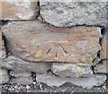
Ordnance Survey Cut Mark
This OS cut mark can be found on the wall of No113 Cimla Road. It marks a point 73.179m above mean sea level.
Image: © Adrian Dust
Taken: 29 Aug 2019
0.01 miles
2
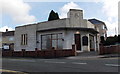
Cimla Funeral Home, Neath
Located at 112 Cimla Road, on the corner of Myrtle Road. The 1930s Art Deco building,
formerly the Co-Operative Society Cimla Branch, was Grade II listed in 1989.
Image: © Jaggery
Taken: 16 Feb 2014
0.06 miles
3

Bohgan Cimla Stores, Neath
A Premier convenience store at 149 Cimla Road.
Image: © Jaggery
Taken: 16 Feb 2014
0.06 miles
4
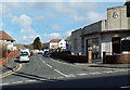
Myrtle Road, Neath
Viewed across Cimla Road. A Grade II listed 1930s Art Deco building http://www.geograph.org.uk/photo/3849645 is on the right.
Image: © Jaggery
Taken: 16 Feb 2014
0.07 miles
5
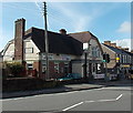
The Cimla, Cimla, Neath
The Cimla pub (formerly the Cimla Hotel), was built in the 1930s.
It is located near the SE end of Cimla Road in the Cimla area of Neath.
Image: © Jaggery
Taken: 16 Feb 2014
0.07 miles
6
Cimla Close, Neath
On the south side of Cimla Road.
Image: © Jaggery
Taken: 16 Feb 2014
0.07 miles
7
British Heart Foundation Clothing Bank, Cimla, Neath
Located at the edge of The Cimla pub. http://www.geograph.org.uk/photo/3849713 The red bin is a British Heart Foundation Clothing Bank,
for donation of clothes and other items to be sold in British Heart Foundation charity shops.
Image: © Jaggery
Taken: 16 Feb 2014
0.08 miles
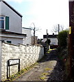
8
Fenced-off Cimla RFC clubhouse, Neath
The site, set back 25 metres from the west side of Cimla Road,
was fenced at the mid-February 2014 date of this view.
Image: © Jaggery
Taken: 16 Feb 2014
0.09 miles
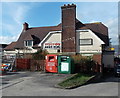
9
CK's Foodstore and post office, Cimla, Neath
Nisa Local store and post office on the west side of Cimla Road, opposite the SE end of Cimla Crescent.
Image: © Jaggery
Taken: 16 Feb 2014
0.10 miles
10
Kenway Avenue, Neath
Viewed across the B4287 Cimla Road.
Image: © Jaggery
Taken: 16 Feb 2014
0.12 miles