IMAGES TAKEN NEAR TO
Heol Dyddwr, NEATH, SA11 3PZ
Introduction
This page details the photographs taken nearby to Heol Dyddwr, SA11 3PZ by members of the Geograph project.
The Geograph project started in 2005 with the aim of publishing, organising and preserving representative images for every square kilometre of Great Britain, Ireland and the Isle of Man.

There are currently over 7.5m images from over14,400 individuals and you can help contribute to the project by visiting https://www.geograph.org.uk
Image Map (Loading...)


Getting Data...Please wait
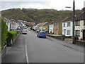
Leaflet Map data © OpenStreetMap
Images are licensed for reuse under creativecommons.org/licenses/by-sa/2.0
Notes
- Clicking on the map will re-center to the selected point.
- The higher the marker number, the further away the image location is from the centre of the postcode.
Image Listing (80 Images Found)
Images are licensed for reuse under creativecommons.org/licenses/by-sa/2.0
Image
Details
Distance
1
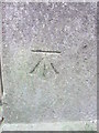
Ordnance Survey Cut Mark
This OS cut mark can be found on the SE parapet of the bridge over a stream at the northern end of Park Street. It marks a point 27.716m above mean sea level.
Image: © Adrian Dust
Taken: 11 Jan 2015
0.06 miles
2
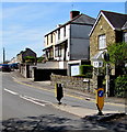
Heol Caredig, Tonna
Unclassified road on the southeast side of the B4434, the main road through Tonna.
Image: © Jaggery
Taken: 3 May 2016
0.06 miles
3
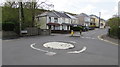
Mini-roundabout in Tonna
At the 3-way junction of Tonna Uchaf, Park Street and Dulais Fach Road.
Image: © Jaggery
Taken: 3 May 2016
0.07 miles
4
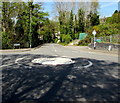
Shadows on a mini-roundabout, Tonna
Looking west towards the B4434 Dulais Fach Road.
Image: © Jaggery
Taken: 5 May 2016
0.07 miles
5
Keep Left sign, Park Street, Tonna
On a small triangular island in the middle of the B4434.
Image: © Jaggery
Taken: 5 May 2016
0.07 miles
6
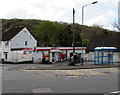
Spar shop, Tonna
On the corner of the B4434 Tonna Uchaf and Heol Caredig.
Image: © Jaggery
Taken: 3 May 2016
0.07 miles
7
Junction of Tonna Uchaf and Heol Caredig, Tonna
Looking along Heol Caredig across the B4434 Tonna Uchaf.
Image: © Jaggery
Taken: 3 May 2016
0.07 miles
8
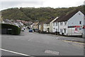
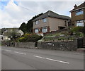
Houses above the main road through Tonna
Houses above the north side of the B4434 Tonna Uchaf.
Image: © Jaggery
Taken: 29 Apr 2016
0.08 miles
9
Houses above Tonna Uchaf, Tonna
Here named Tonna Uchaf, the B4434 is the main road through Tonna.
Image: © Jaggery
Taken: 3 May 2016
0.08 miles
10
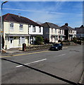
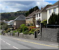
Park Street semis, Tonna
Semi-detached houses on the NE side of the B4434 Park Street, NE of the Park Field junction. https://www.geograph.org.uk/photo/6031948
Image: © Jaggery
Taken: 5 May 2016
0.08 miles