IMAGES TAKEN NEAR TO
James Street, NEATH, SA11 3NE
Introduction
This page details the photographs taken nearby to James Street, SA11 3NE by members of the Geograph project.
The Geograph project started in 2005 with the aim of publishing, organising and preserving representative images for every square kilometre of Great Britain, Ireland and the Isle of Man.

There are currently over 7.5m images from over14,400 individuals and you can help contribute to the project by visiting https://www.geograph.org.uk
Image Map
Images are licensed for reuse under creativecommons.org/licenses/by-sa/2.0
Notes
- Clicking on the map will re-center to the selected point.
- The higher the marker number, the further away the image location is from the centre of the postcode.
Image Listing (406 Images Found)
Images are licensed for reuse under creativecommons.org/licenses/by-sa/2.0
Image
Details
Distance
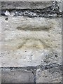
1
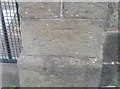
Ordnance Survey Cut Mark
This OS cut mark can be found on the gatepost of The Friends Meeting House. It marks a point 7.471m above mean sea level.
Image: © Adrian Dust
Taken: 6 Jun 2020
0.00 miles
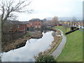
2
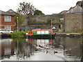
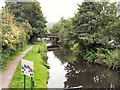
Castle Quay, Neath Canal
The Neath Canal is a typical narrow Welsh Valley canal. It was opened in 1795 and runs from Briton Ferry on the estuary of the River Neath, to Glynneath. The canal is 13½ miles long.
Image: © David Dixon
Taken: 8 Sep 2011
0.01 miles
3
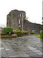
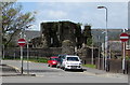
Neath Castle
Neath Castle, in the centre of the town, was one of the minor Norman castles in the lordship of Glamorgan guarding the river crossing for a stronghold. It was established by Robert, Earl of Gloucester, some time between 1114 and 1130. The main surviving feature of the castle is the great twin-towered gatehouse on its west side. This belongs to 14th century rebuilding.
Image: © David Dixon
Taken: 8 Sep 2011
0.02 miles
5
Marker Post
National Cycle Network 47 post
Image: © Alan Roberts
Taken: 4 Aug 2005
0.03 miles
6
Neath Canal
The Neath Canal is a typical narrow Welsh Valley canal. It was opened in 1795 and runs from Briton Ferry on the estuary of the River Neath, to Glynneath. The canal is 13½ miles long.
Image: © David Dixon
Taken: 8 Sep 2011
0.03 miles
7
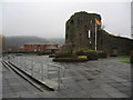
Remains of Neath Castle
Viewed along Castle Street. The Castle Wales website states that Neath Castle was one of the minor Norman castles in the lordship of Glamorgan. Like the Romans before them, the Normans chose this strategic spot guarding the river crossing for a stronghold. The main surviving feature of the castle is the great twin-towered gatehouse on its west side.
The first castle was a ringwork known to have been built here in the 12th century by Robert, Earl of Gloucester. The roughly oval, raised enclosure to the east of the gatehouse probably dates from this period. The castle was much harried by the Welsh, and was rebuilt sometime in the early 13th century, possibly after being destroyed by Llywelyn ap Iorwerth in 1231.
Neath Castle is a Scheduled Ancient Monument and Grade II(star) listed.
Image: © Jaggery
Taken: 3 May 2016
0.03 miles
8
Neath Canal
The Neath Canal is a typical narrow Welsh Valley canal. It was opened in 1795 and runs from Briton Ferry on the estuary of the River Neath, to Glynneath. The canal is 13½ miles long.
Image: © David Dixon
Taken: 8 Sep 2011
0.03 miles
9
Ordnance Survey Cut Mark
This OS cut mark can be found on the corner of the Moose Lodge, once a Methodist Chapel. It marks a point 11.607m above mean sea level.
Image: © Adrian Dust
Taken: 17 Nov 2013
0.04 miles
10
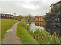
Neath Canal near Riverside Drive, Neath
Viewed from Prince of Wales Drive. Riverside Drive is on the right, located between the canal and the River Neath. Navigation on the Neath Canal ceased in 1934. Recent restoration work removed thousands of tonnes of polluted material from the canal.
Image: © Jaggery
Taken: 19 Feb 2011
0.04 miles