IMAGES TAKEN NEAR TO
Penydre, NEATH, SA11 3HF
Introduction
This page details the photographs taken nearby to Penydre, SA11 3HF by members of the Geograph project.
The Geograph project started in 2005 with the aim of publishing, organising and preserving representative images for every square kilometre of Great Britain, Ireland and the Isle of Man.

There are currently over 7.5m images from over14,400 individuals and you can help contribute to the project by visiting https://www.geograph.org.uk
Image Map
Images are licensed for reuse under creativecommons.org/licenses/by-sa/2.0
Notes
- Clicking on the map will re-center to the selected point.
- The higher the marker number, the further away the image location is from the centre of the postcode.
Image Listing (123 Images Found)
Images are licensed for reuse under creativecommons.org/licenses/by-sa/2.0
Image
Details
Distance
1
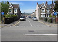
Park Street, Neath
Dead-end street extending for 100 metres from Gnoll Park Road.
Image: © Jaggery
Taken: 5 May 2016
0.03 miles
2
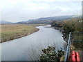
River Neath upstream from Riverside Drive
The view east from an observation area opposite the junction of Riverside Drive, Prince of Wales Drive and Parr Avenue.
Image: © Jaggery
Taken: 19 Feb 2011
0.05 miles
3
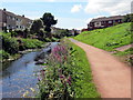
Camlas Nedd / Neath Canal
Camlas Nedd yn mynd drwy'r dref honno.
Neath Canal going through the town.
Image: © Alan Richards
Taken: 5 Aug 2016
0.06 miles
4
Turn right here for the Gnoll Estate, Neath
The white arrow on the brown sign on a Gnoll Park Road lamppost points right towards Harle Street. http://www.geograph.org.uk/photo/4937505
Image: © Jaggery
Taken: 5 May 2016
0.06 miles
5
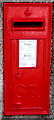
King George V postbox on a Neath corner
Located here. http://www.geograph.org.uk/photo/4937268
The letters GR date the box to the reign
of King George V (May 1910-January 1936).
Image: © Jaggery
Taken: 5 May 2016
0.07 miles
6
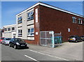
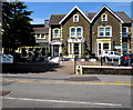
YMCA, Neath
Near the eastern end of Pen-y-dre, viewed from Gnoll Park Road. The Neath YMCA website states that this is a community building which was purpose-built in the 1960s. It has developed from a youth club to a community centre which offers a wide range of facilities and activities designed to meet the needs of the people of Neath and surrounding areas. The YMCA is totally self-funded.
Image: © Jaggery
Taken: 5 May 2016
0.07 miles
7
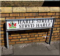
Bilingual Harle Street/Stryd Harle name sign, Neath
The English/Welsh sign is at the NE end of Harle Street, http://www.geograph.org.uk/photo/4937505 on the corner of Gnoll Park Road.
The Neath and Port Talbot Coat of Arms is on the left. The Welsh motto is
LLWYDDO DRWY YMDRECH, which means SUCCEEDING THROUGH ENDEAVOUR.
Image: © Jaggery
Taken: 5 May 2016
0.07 miles
8
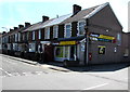
Leonard Street Stores and Post Office, Neath
On the corner of Gnoll Park Road and Leonard Street, the Premier convenience store has a post office inside.
The wall postbox http://www.geograph.org.uk/photo/4937294 is from the reign of King George V (May 1910-January 1936).
Image: © Jaggery
Taken: 5 May 2016
0.08 miles
9
J.J.Lewis Workshop, Neath
Gnoll Monumental Masons at 111 Gnoll Park Road.
Image: © Jaggery
Taken: 5 May 2016
0.08 miles
10
Park View Care Home, Neath
Residential care home at 92-94 Gnoll Park Road.
Image: © Jaggery
Taken: 5 May 2016
0.08 miles