IMAGES TAKEN NEAR TO
Clos Caegwenith, NEATH, SA11 3ER
Introduction
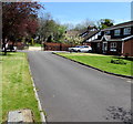
This page details the photographs taken nearby to Clos Caegwenith, SA11 3ER by members of the Geograph project.
The Geograph project started in 2005 with the aim of publishing, organising and preserving representative images for every square kilometre of Great Britain, Ireland and the Isle of Man.

There are currently over 7.5m images from over14,400 individuals and you can help contribute to the project by visiting https://www.geograph.org.uk
Image Map
Images are licensed for reuse under creativecommons.org/licenses/by-sa/2.0
Notes
- Clicking on the map will re-center to the selected point.
- The higher the marker number, the further away the image location is from the centre of the postcode.
Image Listing (36 Images Found)
Images are licensed for reuse under creativecommons.org/licenses/by-sa/2.0
Image
Details
Distance
1
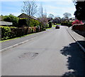
Davies Andrews Road, Wheatfields, Tonna
From the SE side of Neath Road, Davies Andrews Road leads to Clos Caegwenith,
The Paddocks and Hunters Ridge (Crib yr Heliwr in Welsh).
Image: © Jaggery
Taken: 5 May 2016
0.04 miles
2
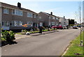
Neath Road semis, Tonna
Semi-detached houses alongside a side road parallel with the B4434 Neath Road.
Image: © Jaggery
Taken: 5 May 2016
0.07 miles
3
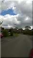
Davies Andrews Road, Tonna
A residential street which leads off the B4434 onto a modern housing estate.
Image: © Helen
Taken: 30 Apr 2015
0.07 miles
4
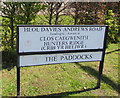
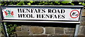
Partly bilingual name signs on a Tonna corner
On the corner of Neath Road and Davies Andrews Road (Heol Davies Andrews in Welsh).
No English equivalent for the Welsh Clos Caegwenith is shown.
No Welsh equivalent for The Paddocks is shown.
Hunters Ridge is Crib yr Heliwr in Welsh.
Image: © Jaggery
Taken: 5 May 2016
0.08 miles
5
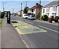
Neath Road bus stop and shelter, Tonna
This stop on the B4434 Neath Road is for buses to Neath. SAFLE BWS is Welsh for BUS STOP.
Image: © Jaggery
Taken: 5 May 2016
0.10 miles
6
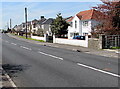
Neath Road houses, Tonna
Viewed across the B4434 Neath Road.
Image: © Jaggery
Taken: 5 May 2016
0.10 miles
7
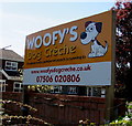
Woofy's Dog Creche nameboard, Tonna
Facing Neath Road at the edge of the business at 70 Neath Road. https://www.geograph.org.uk/photo/6027171
Image: © Jaggery
Taken: 5 May 2016
0.10 miles
8
Woofy's Dog Creche, Tonna
At 70 Neath Road. https://www.geograph.org.uk/photo/6027167 to a closer view of the nameboard.
Image: © Jaggery
Taken: 5 May 2016
0.10 miles
9
Access road to Woofy's Dog Creche, Tonna
The side road is parallel with the B4434 Neath Road.
The distant gates are at the entrance to Woofy's Dog Creche. https://www.geograph.org.uk/photo/6027171
Image: © Jaggery
Taken: 5 May 2016
0.10 miles
10
Henfaes Road/Heol Henfaes name sign, Tonna
The English/Welsh sign is located here. https://www.geograph.org.uk/photo/6027151 The notice on the right shows CLEAN UP AFTER YOUR DOG. MAXIMUM PENALTY £1,000. The text is also in Welsh. The Neath Port Talbot County Borough coat of arms is on the left.
Image: © Jaggery
Taken: 5 May 2016
0.11 miles