IMAGES TAKEN NEAR TO
Woodview, NEATH, SA11 3BX
Introduction
This page details the photographs taken nearby to Woodview, SA11 3BX by members of the Geograph project.
The Geograph project started in 2005 with the aim of publishing, organising and preserving representative images for every square kilometre of Great Britain, Ireland and the Isle of Man.

There are currently over 7.5m images from over14,400 individuals and you can help contribute to the project by visiting https://www.geograph.org.uk
Image Map (Loading...)


Getting Data...Please wait
Leaflet Map data © OpenStreetMap
Images are licensed for reuse under creativecommons.org/licenses/by-sa/2.0
Notes
- Clicking on the map will re-center to the selected point.
- The higher the marker number, the further away the image location is from the centre of the postcode.
Image Listing (5 Images Found)
Images are licensed for reuse under creativecommons.org/licenses/by-sa/2.0
Image
Details
Distance
1
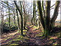
Llwybr tuag at Bant Preswylfa / Path towards Preswylfa Dingle
Llwybr cyhoeddus yn mynd i gyfeiriad Pant Preswylfa.
A public footpath heading towards Preswylfa (dwelling place) Dingle.
Image: © Alan Richards
Taken: 30 Jan 2019
0.05 miles
2
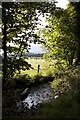
Brynau Woods
A view from Cimla (Brynau Woods) down toward Neath
Image: © Lee
Taken: 31 Aug 2011
0.08 miles
3
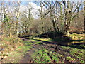
Cyffordd o lwybrau / A junction of paths
Cyffordd o lwybrau ger Coed Brynau.
A junction of paths near Brynau Wood (trans. hills).
Image: © Alan Richards
Taken: 30 Jan 2019
0.09 miles
4
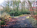
Llwybr ger Coed Brynau / Path near Brynau Wood
Llwybr cyhoeddus acha thro ger Coed Brynau.
A public footpath at a bend near Brynau Wood (trans. hills).
Image: © Alan Richards
Taken: 30 Jan 2019
0.15 miles
5
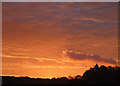
Sunrise over the Gnoll
Sunrise over the Gnoll.
Image: © Robert Davies
Taken: 25 Oct 2008
0.24 miles