IMAGES TAKEN NEAR TO
Afan Valley Road, NEATH, SA11 3AZ
Introduction
This page details the photographs taken nearby to Afan Valley Road, SA11 3AZ by members of the Geograph project.
The Geograph project started in 2005 with the aim of publishing, organising and preserving representative images for every square kilometre of Great Britain, Ireland and the Isle of Man.

There are currently over 7.5m images from over14,400 individuals and you can help contribute to the project by visiting https://www.geograph.org.uk
Image Map
Images are licensed for reuse under creativecommons.org/licenses/by-sa/2.0
Notes
- Clicking on the map will re-center to the selected point.
- The higher the marker number, the further away the image location is from the centre of the postcode.
Image Listing (4 Images Found)
Images are licensed for reuse under creativecommons.org/licenses/by-sa/2.0
Image
Details
Distance
1
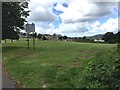
Cimla Common
View across Cimla Common towards the fire station.
Image: © Alan Hughes
Taken: 20 Jul 2017
0.16 miles
2
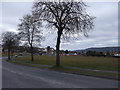
Looking across Cimla Common towards the Fire Station
Image: © John Lord
Taken: 13 Mar 2010
0.21 miles
3
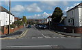
Cimla Crescent, Cimla, Neath
Viewed across Cimla Road. This is the SE end of Cimla Crescent. Its NW end also joins Cimla Road,
about 600 metres away. Most of the Cimla Crescent houses are on a bank of Gnoll Brook.
Image: © Jaggery
Taken: 16 Feb 2014
0.23 miles
4
NEW
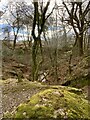
Preswylfa Dingle
Mossy boulder above Cwm Preswylfa.
Image: © Alan Hughes
Taken: 12 Mar 2025
0.23 miles