IMAGES TAKEN NEAR TO
Furnace Place, NEATH, SA11 2FA
Introduction
This page details the photographs taken nearby to Furnace Place, SA11 2FA by members of the Geograph project.
The Geograph project started in 2005 with the aim of publishing, organising and preserving representative images for every square kilometre of Great Britain, Ireland and the Isle of Man.

There are currently over 7.5m images from over14,400 individuals and you can help contribute to the project by visiting https://www.geograph.org.uk
Image Map
Images are licensed for reuse under creativecommons.org/licenses/by-sa/2.0
Notes
- Clicking on the map will re-center to the selected point.
- The higher the marker number, the further away the image location is from the centre of the postcode.
Image Listing (24 Images Found)
Images are licensed for reuse under creativecommons.org/licenses/by-sa/2.0
Image
Details
Distance
1
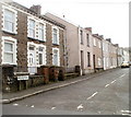
Helen's Road, Melincryddan, Neath
Houses on the east side of the street, viewed from the corner of Herbert Road. http://www.geograph.org.uk/photo/2284964
Image: © Jaggery
Taken: 19 Feb 2011
0.03 miles
2
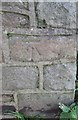
Ordnance Survey Cut Mark
This OS cut mark can be found on the wall on the SE side of Morgans Road. It marks a point 15.837m above mean sea level.
Image: © Adrian Dust
Taken: 23 Aug 2016
0.05 miles
3
470,245 resolutions broken, Mile End Row, Neath
Viewed from a railway footbridge. http://www.geograph.org.uk/photo/2283646
An obviously meaningless and false statistic (470,245 resolutions already broken in Wales) is part of a large advertising banner for a health club. The house is on the corner of Mile End Row and Herbert Road.
Image: © Jaggery
Taken: 19 Feb 2011
0.05 miles
4
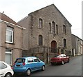
Ebenezer Baptist Church, Melincryddan, Neath
Located on Herbert Road. The church was built in 1863.
Image: © Jaggery
Taken: 19 Feb 2011
0.05 miles
5
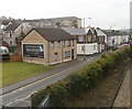
Furnace Terrace
Furnace Terrace faces the A474 just past the junction. Running parallel to the road here are railway and canal which is just out of sight behind the tree and bushes to the right (northwest)
Image: © Steve Rigg
Taken: 5 Feb 2006
0.06 miles
6
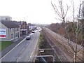
Neath : A474 heads towards Briton Ferry
Viewed from a railway footbridge. http://www.geograph.org.uk/photo/2283646
The silver car is pulling out of Herbert Road, beyond which point the A474 Mile End Row is renamed A474 Furnace Terrace. The South Wales main railway line is on the right, between Neath Station and Briton Ferry Station.
Image: © Jaggery
Taken: 19 Feb 2011
0.06 miles
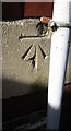
7
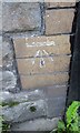
Ordnance Survey Cut Mark
This OS cut mark can be found on No1A Furnace Terrace. It marks a point 7.227m above mean sea level.
Image: © Adrian Dust
Taken: 23 Aug 2016
0.09 miles
8
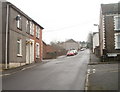
Herbert Road, Melincryddan, Neath
Herbert Road climbs away from the A474, past the turning for Helen's Road. http://www.geograph.org.uk/photo/2284973
Image: © Jaggery
Taken: 19 Feb 2011
0.09 miles
9
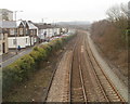
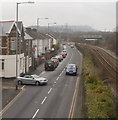
Neath : South Wales main line alongside the A474
Viewed from a footbridge. http://www.geograph.org.uk/photo/2283646
Briton Ferry station is about a mile (1600 metres) away.
Image: © Jaggery
Taken: 19 Feb 2011
0.10 miles
10
Ordnance Survey Cut Mark
This OS cut mark can be found on the front of Pencaerau School. It marks a point 21.741m above mean sea level.
Image: © Adrian Dust
Taken: 23 Aug 2016
0.11 miles