IMAGES TAKEN NEAR TO
St. Catherines Close, NEATH, SA11 2DU
Introduction
This page details the photographs taken nearby to St. Catherines Close, SA11 2DU by members of the Geograph project.
The Geograph project started in 2005 with the aim of publishing, organising and preserving representative images for every square kilometre of Great Britain, Ireland and the Isle of Man.

There are currently over 7.5m images from over14,400 individuals and you can help contribute to the project by visiting https://www.geograph.org.uk
Image Map (Loading...)


Getting Data...Please wait
Leaflet Map data © OpenStreetMap
Images are licensed for reuse under creativecommons.org/licenses/by-sa/2.0
Notes
- Clicking on the map will re-center to the selected point.
- The higher the marker number, the further away the image location is from the centre of the postcode.
Image Listing (34 Images Found)
Images are licensed for reuse under creativecommons.org/licenses/by-sa/2.0
Image
Details
Distance
1
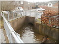
Cryddan Brook emerges from a tunnel under Briton Ferry Road, Neath
The brook, spelt Cryddan or Crythan, after passing under Briton Ferry Road, flows around the edge of Castle Bingo. http://www.geograph.org.uk/photo/2283474
Image: © Jaggery
Taken: 19 Feb 2011
0.06 miles
2
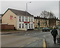
Jasmine Spice, Neath
Takeaway at 135 Briton Ferry Road. A large sign on the side of the building will appeal to those who enjoy a challenge "ALL YOU CAN EAT BUFFET FROM £7.95"
The premises have had various occupiers in recent years, including The Olive Tree restaurant.
Image: © Jaggery
Taken: 19 Feb 2011
0.06 miles
3
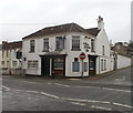
The Royal Exchange Inn, Neath
109 Briton Ferry Road, on the corner of Exchange Road.
Image: © Jaggery
Taken: 19 Feb 2011
0.07 miles
4
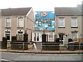
Neath Boys and Girls Club
71 Briton Ferry Road, set back a couple of metres from the pavement.
The sedate NEATH BOYS CLUB sign at the entrance, from an earlier era, contrasts with modern blue mural - and the modern name of the club.
Image: © Jaggery
Taken: 19 Feb 2011
0.07 miles
5
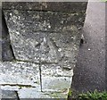
Ordnance Survey Cut Mark
This OS cut mark can be found on the SW face of St Catherine's Church. It marks a point 21.278m above mean sea level.
Image: © Adrian Dust
Taken: 23 Aug 2016
0.10 miles
6
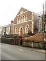
Siloh Chapel, Neath
Congregational chapel on Old Road, Melincryddan, Neath. It was opened in 1880, built on land given by the Earl of Jersey in 1878.
Image: © Jaggery
Taken: 19 Feb 2011
0.12 miles
7
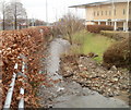
Cryddan Brook, Neath
Spelt Cryddan or Crythan, the brook here flows parallel with Briton Ferry Road (A474). In the background are Castle Bingo http://www.geograph.org.uk/photo/2283481 and Lidl. http://www.geograph.org.uk/photo/2283489
Image: © Jaggery
Taken: 19 Feb 2011
0.12 miles
8
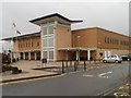
Castle Bingo, Neath
Located in the south of Neath, facing Briton Ferry Road. Castle Bingo opened here in April 2003.
Image: © Jaggery
Taken: 19 Feb 2011
0.12 miles
9
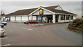
Lidl, Briton Ferry Road, Neath
Located on the west side of Briton Ferry Road, near to Castle Bingo. http://www.geograph.org.uk/photo/2283481
Image: © Jaggery
Taken: 19 Feb 2011
0.12 miles
10
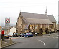
Church of St Catherine, Neath
Church in Wales church on the corner of School Road and Old Road, Melincryddan, Neath. Consecrated in 1891, the church is dedicated to Catherine of Alexandria whose symbolic Catherine Wheel is incorporated in the reredos (ornamental screen covering the wall at the back of the altar).
Image: © Jaggery
Taken: 19 Feb 2011
0.13 miles