IMAGES TAKEN NEAR TO
Cook Rees Avenue, NEATH, SA11 1UR
Introduction
This page details the photographs taken nearby to Cook Rees Avenue, SA11 1UR by members of the Geograph project.
The Geograph project started in 2005 with the aim of publishing, organising and preserving representative images for every square kilometre of Great Britain, Ireland and the Isle of Man.

There are currently over 7.5m images from over14,400 individuals and you can help contribute to the project by visiting https://www.geograph.org.uk
Image Map (Loading...)


Getting Data...Please wait
Leaflet Map data © OpenStreetMap
Images are licensed for reuse under creativecommons.org/licenses/by-sa/2.0
Notes
- Clicking on the map will re-center to the selected point.
- The higher the marker number, the further away the image location is from the centre of the postcode.
Image Listing (18 Images Found)
Images are licensed for reuse under creativecommons.org/licenses/by-sa/2.0
Image
Details
Distance
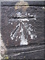
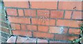
1
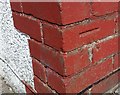
Ordnance Survey Cut Mark
This OS cut mark can be found on No14 Caederwen. It marks a point 62.230m above mean sea level.
Image: © Adrian Dust
Taken: 29 Aug 2019
0.08 miles
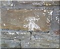
2
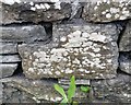
Ordnance Survey Cut Mark
This OS cut mark can be found on the wall of Fernbank, Hillside. It marks a point 30.643m above mean sea level.
Image: © Adrian Dust
Taken: 29 Aug 2019
0.10 miles
3
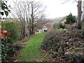
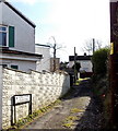
Llwybr Cyhoeddus yng Nghimla / A public footpath in Cimla
Llwybr cyhoeddus yng Nghimla yn agosau at heol.
A public footpath in Cimla approaching a road.
Image: © Alan Richards
Taken: 30 Jan 2019
0.11 miles
4
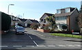
Kenway Avenue, Neath
Viewed across the B4287 Cimla Road.
Image: © Jaggery
Taken: 16 Feb 2014
0.13 miles
5
Ordnance Survey Cut Mark
This OS cut mark can be found on the wall to the SE of Hillside. It marks a point 37.445m above mean sea level.
Image: © Adrian Dust
Taken: 15 Dec 2013
0.14 miles
6
Ordnance Survey Cut Mark
This OS cut mark can be found on the wall north side of Hillside. It marks a point 33.687m above mean sea level.
Image: © Adrian Dust
Taken: 29 Aug 2019
0.16 miles
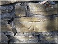
7
Ordnance Survey Cut Mark
This OS cut mark can be found on the wall east side of Kingdom Owen Road. It marks a point 86.905m above mean sea level.
Image: © Adrian Dust
Taken: 29 Aug 2019
0.16 miles
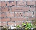
8
Ordnance Survey Cut Mark
This OS cut mark can be found on the wall of No63 Dalton Road. It marks a point 42.837m above mean sea level.
Image: © Adrian Dust
Taken: 29 Aug 2019
0.16 miles
9
Cimla Close, Neath
On the south side of Cimla Road.
Image: © Jaggery
Taken: 16 Feb 2014
0.16 miles
10
Ordnance Survey Cut Mark
This OS cut mark can be found on the brick post west side of Burnside. It marks a point 51.813m above mean sea level.
Image: © Adrian Dust
Taken: 29 Aug 2019
0.17 miles