IMAGES TAKEN NEAR TO
George Street, NEATH, SA11 1TT
Introduction
This page details the photographs taken nearby to George Street, SA11 1TT by members of the Geograph project.
The Geograph project started in 2005 with the aim of publishing, organising and preserving representative images for every square kilometre of Great Britain, Ireland and the Isle of Man.

There are currently over 7.5m images from over14,400 individuals and you can help contribute to the project by visiting https://www.geograph.org.uk
Image Map (Loading...)


Getting Data...Please wait
Leaflet Map data © OpenStreetMap
Images are licensed for reuse under creativecommons.org/licenses/by-sa/2.0
Notes
- Clicking on the map will re-center to the selected point.
- The higher the marker number, the further away the image location is from the centre of the postcode.
Image Listing (82 Images Found)
Images are licensed for reuse under creativecommons.org/licenses/by-sa/2.0
Image
Details
Distance
1
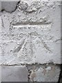
Ordnance Survey Cut Mark
This OS cut mark can be found on No7 Lewis Road. It marks a point 13.430m above mean sea level.
Image: © Adrian Dust
Taken: 15 Dec 2013
0.06 miles
2
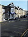
Quest in Neath
A "One Stop Shop" convenience store on the corner of Lewis Road and Llewellyn Street.
Image: © Jaggery
Taken: 16 Feb 2014
0.06 miles
3
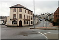
The Highlander, Neath
Pub and restaurant, 2-4 Lewis Road, opposite Neath Methodist Church. http://www.geograph.org.uk/photo/2282572
Image: © Jaggery
Taken: 19 Feb 2011
0.06 miles
4
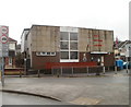
Royal British Legion, Neath
Located at the SW end of Eastland Road, opposite Stockham's Corner. http://www.geograph.org.uk/photo/226288
Image: © Jaggery
Taken: 19 Feb 2011
0.06 miles
5
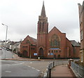
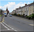
Neath Methodist Church
Located between the northern ends of Briton Ferry Road (A474) and Lewis Road, opposite a junction known as Stockham’s Corner. http://www.geograph.org.uk/photo/226288 The church is known locally as the Penny-brick Church, because local people donated a penny towards the cost of each brick needed to build it.
Image: © Jaggery
Taken: 19 Feb 2011
0.06 miles
6
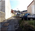
Quar Road, Neath
Viewed from the Briton Ferry Road end looking past the edge of Springfield Terrace on the left.
Image: © Jaggery
Taken: 16 Feb 2014
0.08 miles
7
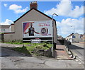
X-Men Apocalypse advert on a Neath wall
On April 29th 2016, the X-Men character Storm is depicted on a Lightning Fast Sky Fibre advert on a Primesight board. The location is the side wall on the corner of the A474 Briton Ferry Road and Quar Road.
Image: © Jaggery
Taken: 29 Apr 2016
0.08 miles
8
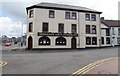
Highlander bar & restaurant, Neath
At 2-4 Lewis Road, opposite Neath Methodist Church. http://www.geograph.org.uk/photo/4959792
Image: © Jaggery
Taken: 29 Apr 2016
0.09 miles
9
Eastland Road, Neath
From the corner of Eastland Place along the B4434 Eastland Road towards Neath Methodist Church. http://www.geograph.org.uk/photo/4959792
Image: © Jaggery
Taken: 29 Apr 2016
0.09 miles
10
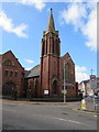
Neath Methodist Church
Part of the Neath Port Talbot Methodist Circuit,
Neath Methodist Church is located at Stockham's Corner.
The Methodist churches in Aberdulais, Briton Ferry and London Road merged
with Windsor Square to form the present-day church, viewed in April 2016.
Image: © Jaggery
Taken: 29 Apr 2016
0.09 miles