IMAGES TAKEN NEAR TO
London Road, NEATH, SA11 1LF
Introduction
This page details the photographs taken nearby to London Road, SA11 1LF by members of the Geograph project.
The Geograph project started in 2005 with the aim of publishing, organising and preserving representative images for every square kilometre of Great Britain, Ireland and the Isle of Man.

There are currently over 7.5m images from over14,400 individuals and you can help contribute to the project by visiting https://www.geograph.org.uk
Image Map
Images are licensed for reuse under creativecommons.org/licenses/by-sa/2.0
Notes
- Clicking on the map will re-center to the selected point.
- The higher the marker number, the further away the image location is from the centre of the postcode.
Image Listing (403 Images Found)
Images are licensed for reuse under creativecommons.org/licenses/by-sa/2.0
Image
Details
Distance
1
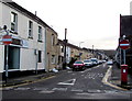
One-way Greenway Road, Neath
On the east side of London Road opposite the Ropewalk.
Image: © Jaggery
Taken: 3 Jan 2020
0.03 miles
2
South side of Greenway Road, Neath
Looking past London Road Presbyterian Church http://www.geograph.org.uk/photo/2282295
towards the Victoria Gardens and Eastland Road junction.
Image: © Jaggery
Taken: 16 Feb 2014
0.04 miles
3
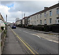
NNE along Eastland Road, Neath
The B4434 Eastland Road viewed from the corner of Geoffrey Street.
Image: © Jaggery
Taken: 29 Apr 2016
0.04 miles
4
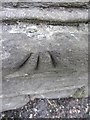
Ordnance Survey Rivet
This OS rivet can be found on the wall of No3 Greenway Road. It marks a point 13.116m above mean sea level.
Image: © Adrian Dust
Taken: 17 Nov 2013
0.04 miles
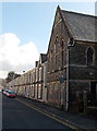
5
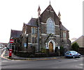
London Road Presbyterian Church, Neath
Church dated 1880 on the corner of London Road and Greenway Road.
Image: © Jaggery
Taken: 3 Jan 2020
0.05 miles
6

Entrance to a military site in Neath
The entrance to the Territorial Army and Army Cadet Force centre
is on the corner of Eastland Road and Cimla Road.
Image: © Jaggery
Taken: 16 Feb 2014
0.05 miles
7
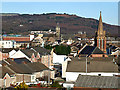
A rooftop view of Neath
Two church steeples rise above the roofs of Neath. The nearest is known locally as the 'Penny Brick' church. It was built by public subscription, and a penny donated would pay for one brick. The other church is St Davids.
Image: © Robert Davies
Taken: 3 Jan 2009
0.05 miles
8
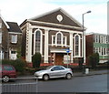
Bethania Baptist Church, Neath
Located on London Road, viewed from Creswell Road. The church, dating from 1805, was built in the Classical style. It was awarded Grade II listing in 1989.
Image: © Jaggery
Taken: 19 Feb 2011
0.06 miles
9
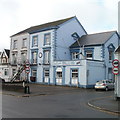
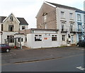
RAFA club, Neath
The Royal Air Forces Association Neath 617 Branch and Club is located on the corner of London Road and Ropewalk. A 3-blade propeller is on the flat roof at the right.
Image: © Jaggery
Taken: 19 Feb 2011
0.06 miles
10
Neath Central Club & Institute
Located on London Road, next door to the RAF club. http://www.geograph.org.uk/photo/2282256
Image: © Jaggery
Taken: 19 Feb 2011
0.06 miles