IMAGES TAKEN NEAR TO
Cae Rhys Ddu Road, NEATH, SA11 1JA
Introduction
This page details the photographs taken nearby to Cae Rhys Ddu Road, SA11 1JA by members of the Geograph project.
The Geograph project started in 2005 with the aim of publishing, organising and preserving representative images for every square kilometre of Great Britain, Ireland and the Isle of Man.

There are currently over 7.5m images from over14,400 individuals and you can help contribute to the project by visiting https://www.geograph.org.uk
Image Map
Images are licensed for reuse under creativecommons.org/licenses/by-sa/2.0
Notes
- Clicking on the map will re-center to the selected point.
- The higher the marker number, the further away the image location is from the centre of the postcode.
Image Listing (20 Images Found)
Images are licensed for reuse under creativecommons.org/licenses/by-sa/2.0
Image
Details
Distance
1

Ordnance Survey Rivet
This OS rivet can be found on the step of No7 Cae Rhys Ddu Road. It marks a point 105.699m above mean sea level.
Image: © Adrian Dust
Taken: 29 Aug 2019
0.02 miles
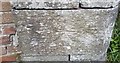
3

Ordnance Survey Cut Mark
This OS cut mark can be found on the Fire Station. It marks a point 86.636m above mean sea level.
Image: © Adrian Dust
Taken: 29 Aug 2019
0.12 miles
4
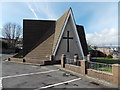
South side of the Church of St Peter & St Paul, Cimla, Neath
The Anglican (Church in Wales) church is located on the west side of the B4287 Cimla Road.
It is part of the Rectorial Benefice of Neath in the Diocese of Llandaff.
The octagonal church building was consecrated and opened in May 1970.
http://www.geograph.org.uk/photo/3964377 to a view of the north side.
Image: © Jaggery
Taken: 16 Feb 2014
0.13 miles
5
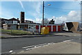
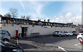
Neath Fire Station
Part of the Mid and West Wales Fire and Rescue Service, Neath Fire Station is on the corner of Cimla Road and Cae Rhys Ddu in the Cimla area of Neath. It serves the town and surrounding communities, and also provides operational support for neighbouring stations in the Neath Valley, Dulais Valley and Afan Valley. Neath station is currently (early 2014) crewed by 28 personnel working a whole-time duty shift system.
The large yellow bin is for donations to the Fire Fighters Charity.
Image: © Jaggery
Taken: 16 Feb 2014
0.13 miles
6
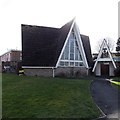
North side of the Church of St Peter & St Paul, Cimla, Neath
The Anglican (Church in Wales) church is located on the west side of the B4287 Cimla Road.
It is part of the Rectorial Benefice of Neath in the Diocese of Llandaff.
The octagonal church building was consecrated and opened in May 1970.
http://www.geograph.org.uk/photo/3964385 to a view of the south side
Image: © Jaggery
Taken: 16 Feb 2014
0.13 miles
7
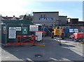
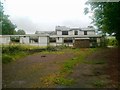
Fenced-off Cimla RFC clubhouse, Neath
The site, set back 25 metres from the west side of Cimla Road,
was fenced at the mid-February 2014 date of this view.
Image: © Jaggery
Taken: 16 Feb 2014
0.14 miles
8
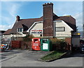
CK's Foodstore and post office, Cimla, Neath
Nisa Local store and post office on the west side of Cimla Road, opposite the SE end of Cimla Crescent.
Image: © Jaggery
Taken: 16 Feb 2014
0.15 miles
9
Ordnance Survey Cut Mark
This OS cut mark can be found on the post NE side of the track. It marks a point 90.992m above mean sea level.
Image: © Adrian Dust
Taken: 29 Aug 2019
0.16 miles
10
British Heart Foundation Clothing Bank, Cimla, Neath
Located at the edge of The Cimla pub. http://www.geograph.org.uk/photo/3849713 The red bin is a British Heart Foundation Clothing Bank,
for donation of clothes and other items to be sold in British Heart Foundation charity shops.
Image: © Jaggery
Taken: 16 Feb 2014
0.16 miles