IMAGES TAKEN NEAR TO
The Ropewalk, NEATH, SA11 1ES
Introduction
This page details the photographs taken nearby to The Ropewalk, SA11 1ES by members of the Geograph project.
The Geograph project started in 2005 with the aim of publishing, organising and preserving representative images for every square kilometre of Great Britain, Ireland and the Isle of Man.

There are currently over 7.5m images from over14,400 individuals and you can help contribute to the project by visiting https://www.geograph.org.uk
Image Map (Loading...)


Getting Data...Please wait
Leaflet Map data © OpenStreetMap
Images are licensed for reuse under creativecommons.org/licenses/by-sa/2.0
Notes
- Clicking on the map will re-center to the selected point.
- The higher the marker number, the further away the image location is from the centre of the postcode.
Image Listing (578 Images Found)
Images are licensed for reuse under creativecommons.org/licenses/by-sa/2.0
Image
Details
Distance
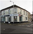
1
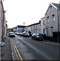
East along The Ropewalk, Neath
This part of The Ropewalk is between Windsor Road and Orchard Street.
Image: © Jaggery
Taken: 3 Jan 2020
0.00 miles
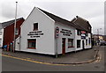
2
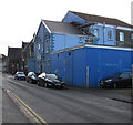
Blue building at the eastern end of the Ropewalk, Neath
Ropewalk side of RAFA (The Royal Air Forces Association) Neath 617 Branch & Club on the corner of London Road.
Image: © Jaggery
Taken: 3 Jan 2020
0.01 miles
3
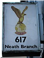
RAFA 617 Neath Branch sign
On the wall above the entrance here. https://www.geograph.org.uk/photo/6362186
Image: © Jaggery
Taken: 3 Jan 2020
0.01 miles
4
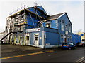
Scaffolding on the London Road side of the RAFA club, Neath
The Royal Air Forces Association Neath 617 Branch & Club on the corner of the Ropewalk on January 3rd 2020.
Image: © Jaggery
Taken: 3 Jan 2020
0.02 miles
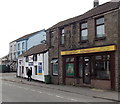
5
Les Davies & Son Funeral Directors, Neath
15 London Road, on the corner of Ropewalk.
Image: © Jaggery
Taken: 1 Mar 2014
0.02 miles
6
New Dragon, Neath
Chinese & Cantonese cuisine takeaway in London Road.
Image: © Jaggery
Taken: 1 Mar 2014
0.03 miles
7
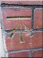
Ordnance Survey Cut Mark
This OS cut mark can be found on the gate post of No7 The Rope Walk. It marks a point 10.903m above mean sea level.
Image: © Adrian Dust
Taken: 17 Nov 2013
0.03 miles
8
Signature Lengths on a Neath corner
Hair extension specialists on the corner of Greenway Road and Orchard Street.
Image: © Jaggery
Taken: 3 Jan 2020
0.03 miles
9
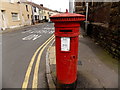
Victorian pillarbox near London Road Presbyterian Church, Neath
On the corner of London Road and Greenway Road, at the edge of this https://www.geograph.org.uk/photo/6362198 church. Grade II listed in 1989
Image: © Jaggery
Taken: 1 Mar 2014
0.03 miles
10
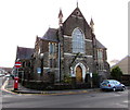
London Road Presbyterian Church, Neath
Church dated 1880 on the corner of London Road and Greenway Road.
Image: © Jaggery
Taken: 3 Jan 2020
0.04 miles