IMAGES TAKEN NEAR TO
Wellfield Avenue, NEATH, SA11 1AX
Introduction
This page details the photographs taken nearby to Wellfield Avenue, SA11 1AX by members of the Geograph project.
The Geograph project started in 2005 with the aim of publishing, organising and preserving representative images for every square kilometre of Great Britain, Ireland and the Isle of Man.

There are currently over 7.5m images from over14,400 individuals and you can help contribute to the project by visiting https://www.geograph.org.uk
Image Map (Loading...)


Getting Data...Please wait
Leaflet Map data © OpenStreetMap
Images are licensed for reuse under creativecommons.org/licenses/by-sa/2.0
Notes
- Clicking on the map will re-center to the selected point.
- The higher the marker number, the further away the image location is from the centre of the postcode.
Image Listing (81 Images Found)
Images are licensed for reuse under creativecommons.org/licenses/by-sa/2.0
Image
Details
Distance
1
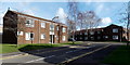
Eastland Place, Neath
Flats on the SE side of Eastland Road.
Image: © Jaggery
Taken: 16 Feb 2014
0.10 miles
2
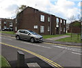
Eastland Place flats, Neath
Viewed from the corner of Eastland Road.
Image: © Jaggery
Taken: 29 Apr 2016
0.10 miles
3
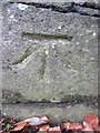
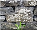
Ordnance Survey Cut Mark
This OS cut mark can be found on the wall of No99 Lewis Road. It marks a point 26.539m above mean sea level.
Image: © Adrian Dust
Taken: 15 Dec 2013
0.11 miles
4
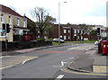
Eastland Road pelican crossing, Neath
Viewed from the corner of Geoffrey Street.
Chambers Dictionary states that "pelican" is adapted from "pedestrian light controlled crossing".
Image: © Jaggery
Taken: 29 Apr 2016
0.11 miles
5
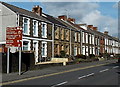
Eastland Road houses, Neath
The brown sign lists several nearby places of interest -
Afan Forest Park, Miners Museum, Neath Leisure Centre, Gnoll Estate and Gwyn Hall.
Image: © Jaggery
Taken: 16 Feb 2014
0.12 miles
6
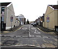
Western end of Bilton Road, Neath
Viewed across the B4434 Eastland Road. The 30mph speed limit drops to 20mph on the approach to a school.
Image: © Jaggery
Taken: 29 Apr 2016
0.12 miles
7
Gnoll Primary School, Neath
Viewed from the north, from the Cimla Road side.
The school's address is Wellfield Avenue, which is on the south side.
Image: © Jaggery
Taken: 16 Feb 2014
0.12 miles
8
Ordnance Survey Cut Mark
This OS cut mark can be found on the wall of Fernbank, Hillside. It marks a point 30.643m above mean sea level.
Image: © Adrian Dust
Taken: 29 Aug 2019
0.12 miles
9
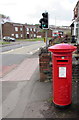
King George VI pillarbox, Eastland Road, Neath
Located here. http://www.geograph.org.uk/photo/4942735
Image: © Jaggery
Taken: 29 Apr 2016
0.12 miles
10
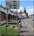
Directions sign facing the B4434 Eastland Road, Neath
Alongside Poppy Court houses. Neath Methodist Church http://www.geograph.org.uk/photo/4959792 is in the background.
Image: © Jaggery
Taken: 29 Apr 2016
0.13 miles