IMAGES TAKEN NEAR TO
Onllwyn Road, NEATH, SA10 9NS
Introduction
This page details the photographs taken nearby to Onllwyn Road, SA10 9NS by members of the Geograph project.
The Geograph project started in 2005 with the aim of publishing, organising and preserving representative images for every square kilometre of Great Britain, Ireland and the Isle of Man.

There are currently over 7.5m images from over14,400 individuals and you can help contribute to the project by visiting https://www.geograph.org.uk
Image Map (Loading...)


Getting Data...Please wait
Leaflet Map data © OpenStreetMap
Images are licensed for reuse under creativecommons.org/licenses/by-sa/2.0
Notes
- Clicking on the map will re-center to the selected point.
- The higher the marker number, the further away the image location is from the centre of the postcode.
Image Listing (10 Images Found)
Images are licensed for reuse under creativecommons.org/licenses/by-sa/2.0
Image
Details
Distance
2
Moorside Villas, Coelbren
Six semi-detached houses on the NE side of the A4221, opposite Price's Row. http://www.geograph.org.uk/photo/2576287
Image: © Jaggery
Taken: 29 Aug 2011
0.10 miles
4
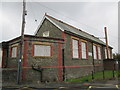
Old School, Coelbren
There is an Ordnance Survey cut mark on the NE angle of the school. http://www.geograph.org.uk/photo/4173414
Image: © Adrian Dust
Taken: 20 Sep 2014
0.15 miles
5
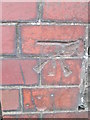
Ordnance Survey Cut Mark
This OS cut mark can be found on the old school building to the south of Cefn Byrle Road. It marks a point 248.144m above mean sea level. http://www.geograph.org.uk/photo/4173421
Image: © Adrian Dust
Taken: 20 Sep 2014
0.15 miles
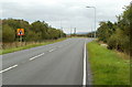
6
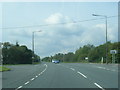
Road Junction on the A4221 near Coelbren
Photograph taken on the Inter Valley Road looking toward Aber-craf.
Image: © Cedwyn Davies
Taken: 30 Aug 2006
0.16 miles
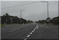
7
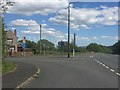
Junction ahead, A4221 near Coelbren
Near the top of the long ascent from Abercraf, the A4221 approaches the junction with Onllwyn Road and Price's Row. http://www.geograph.org.uk/photo/2576287
Image: © Jaggery
Taken: 29 Aug 2011
0.16 miles
8
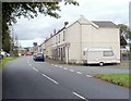
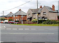
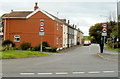
Price's Row, Coelbren, viewed from the west
A row of ten houses on the road to Onllwyn, on the west side of the A4221.
Originally Dickson's Row, the houses were built in the 1860s for railway navvies. Dickson was the contractor in charge of the construction of the Neath and Brecon Railway. http://www.geograph.org.uk/photo/2576287 to a view from the opposite end.
Image: © Jaggery
Taken: 29 Aug 2011
0.16 miles
9
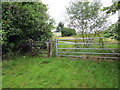
Llwybr ceffyl ger Coelbren / Bridleway near Coelbren
Llwybr ceffyl ger Coelbren yn cyrraedd Heol Onllwyn.
A bridleway near Coelbren about to join Heol Onllwyn (trans. Ashrove Road).
Image: © Alan Richards
Taken: 29 Jul 2020
0.18 miles
10
Price's Row, Coelbren, viewed from the east
Viewed across the A4221. Price's Row contains ten houses, located on the road to Onllwyn. Originally Dickson's Row, built in the 1860s to house railway navvies. Dickson was the contractor in charge of the construction of the Neath and Brecon Railway. http://www.geograph.org.uk/photo/2576273 to a view from the opposite end.
Image: © Jaggery
Taken: 29 Aug 2011
0.18 miles