IMAGES TAKEN NEAR TO
Main Road, NEATH, SA10 9HR
Introduction
This page details the photographs taken nearby to Main Road, SA10 9HR by members of the Geograph project.
The Geograph project started in 2005 with the aim of publishing, organising and preserving representative images for every square kilometre of Great Britain, Ireland and the Isle of Man.

There are currently over 7.5m images from over14,400 individuals and you can help contribute to the project by visiting https://www.geograph.org.uk
Image Map
Images are licensed for reuse under creativecommons.org/licenses/by-sa/2.0
Notes
- Clicking on the map will re-center to the selected point.
- The higher the marker number, the further away the image location is from the centre of the postcode.
Image Listing (32 Images Found)
Images are licensed for reuse under creativecommons.org/licenses/by-sa/2.0
Image
Details
Distance
1
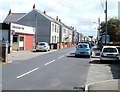
Banwen Food & Wine, Dyffryn Cellwen
Convenience store, 12 Main Road.
Image: © Jaggery
Taken: 4 Sep 2011
0.03 miles
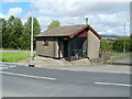
2
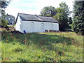
Former Noddfa chapel, Dyffryn Cellwen
Set back about 20 metres from the south side of Main Road. The former Noddfa Wesleyan Methodist Chapel has been disused for at least a decade.
Image: © Jaggery
Taken: 4 Sep 2011
0.07 miles
3
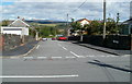
Cross Road, Dyffryn Cellwen
Looking along Cross Road from Main Road.
Image: © Jaggery
Taken: 4 Sep 2011
0.09 miles

5
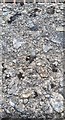
Ordnance Survey Rivet
This OS rivet can be found on the culvert south side of Intervalley Road. It marks a point 237.825m above mean sea level. https://www.geograph.org.uk/photo/6539553
Image: © Adrian Dust
Taken: 17 Jul 2020
0.09 miles
6
Public convenience, Dyffryn Cellwen
Located between Main Road and the A4109, near the western edge of the village. Modern facilities - and open on a Sunday.
Image: © Jaggery
Taken: 4 Sep 2011
0.10 miles
7
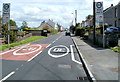
20mph zone, Dyffryn Cellwen
Looking to the SE along Main Road.
Image: © Jaggery
Taken: 4 Sep 2011
0.10 miles
8
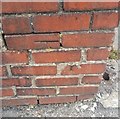
Ordnance Survey Cut Mark
This damaged OS cut mark can be found on the wall of No48 Main Road. It marks a point 246.656m above mean sea level.
Image: © Adrian Dust
Taken: 17 Jul 2020
0.11 miles
9
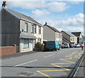
Main Road houses, Dyffryn Cellwen
Viewed from the corner of Cross Road. http://www.geograph.org.uk/photo/2680521
Image: © Jaggery
Taken: 4 Sep 2011
0.11 miles
10
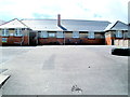
Northern side of Maesmarchog Primary School, Dyffryn Cellwen
Viewed across Main Road.
Image: © Jaggery
Taken: 4 Sep 2011
0.11 miles