IMAGES TAKEN NEAR TO
Neath Road, NEATH, SA10 8SG
Introduction
This page details the photographs taken nearby to Neath Road, SA10 8SG by members of the Geograph project.
The Geograph project started in 2005 with the aim of publishing, organising and preserving representative images for every square kilometre of Great Britain, Ireland and the Isle of Man.

There are currently over 7.5m images from over14,400 individuals and you can help contribute to the project by visiting https://www.geograph.org.uk
Image Map
Images are licensed for reuse under creativecommons.org/licenses/by-sa/2.0
Notes
- Clicking on the map will re-center to the selected point.
- The higher the marker number, the further away the image location is from the centre of the postcode.
Image Listing (9 Images Found)
Images are licensed for reuse under creativecommons.org/licenses/by-sa/2.0
Image
Details
Distance
1
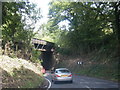
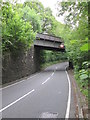
A4109 Neath Road passes under railway bridge
Image: © Colin Pyle
Taken: 19 Sep 2015
0.14 miles
2
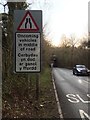
Railway bridge over the A4109 near Crynant
Warning sign that the A4109 narrows as it turns under the railway bridge.
Image: © Alan Hughes
Taken: 1 Dec 2017
0.14 miles
3
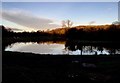
Ty'n y Graig fishery
Low light reflections on the fishery pond at Ty'n y Graig Farm.
Image: © Alan Hughes
Taken: 1 Dec 2017
0.15 miles
4
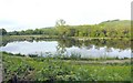
Tyn-y-graig Fishery, Crynant
Trout fishing lakes beside the river Dulais.
Image: © Nigel Davies
Taken: 31 May 2010
0.15 miles
5
Railway Bridge
There is an Ordnance Survey cut mark on the SW buttress. http://www.geograph.org.uk/photo/4071020
Image: © Adrian Dust
Taken: 14 Jul 2014
0.15 miles
6
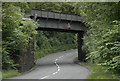
Railway Bridge over the A4109 south of Crynant
The bridge was built along the former 'Neath and Brecon Railway' (originally the 'Dulais Valley Mineral Railway'). The line still survives to Onllwyn Coal Washery.
Image: © Cedwyn Davies
Taken: 30 Aug 2006
0.16 miles
7
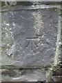
Ordnance Survey Cut Mark
This OS cut mark can be found on the SW buttress of the railway bridge. It marks a point 97.792m above mean sea level. http://www.geograph.org.uk/photo/4071026
Image: © Adrian Dust
Taken: 14 Jul 2014
0.16 miles
8
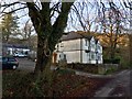
Ty'n y Graig Farm
Ty'n y Graig Farm near Crynant.
Image: © Alan Hughes
Taken: 1 Dec 2017
0.17 miles
9
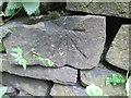
Ordnance Survey Cut Mark
This OS cut mark can be found on a wall to the SE of the road. It marks a point 105.436m above mean sea level.
Image: © Adrian Dust
Taken: 14 Jul 2014
0.22 miles