IMAGES TAKEN NEAR TO
Treforgan Road, NEATH, SA10 8PW
Introduction
This page details the photographs taken nearby to Treforgan Road, SA10 8PW by members of the Geograph project.
The Geograph project started in 2005 with the aim of publishing, organising and preserving representative images for every square kilometre of Great Britain, Ireland and the Isle of Man.

There are currently over 7.5m images from over14,400 individuals and you can help contribute to the project by visiting https://www.geograph.org.uk
Image Map (Loading...)


Getting Data...Please wait
Leaflet Map data © OpenStreetMap
Images are licensed for reuse under creativecommons.org/licenses/by-sa/2.0
Notes
- Clicking on the map will re-center to the selected point.
- The higher the marker number, the further away the image location is from the centre of the postcode.
Image Listing (43 Images Found)
Images are licensed for reuse under creativecommons.org/licenses/by-sa/2.0
Image
Details
Distance
1
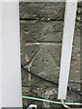
Ordnance Survey Cut Mark
This OS cut mark can be found on No35 Treforgan Road. It marks a point 109.451m above mean sea level.
Image: © Adrian Dust
Taken: 14 Jul 2014
0.03 miles
2
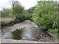
River Dulais, Crynant
Viewed looking to the SW from this http://www.geograph.org.uk/photo/4954871 road bridge. The River Dulais is a tributary of the River Neath.
Image: © Jaggery
Taken: 16 May 2016
0.06 miles
3
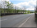
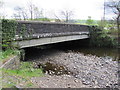
Road bridge over the River Dulais, Crynant
The bridge carries the minor road from Ystradgynlais over the river. http://www.geograph.org.uk/photo/4954861 to a riverside view of the bridge.
Image: © Jaggery
Taken: 16 May 2016
0.09 miles
4
Directions sign on the approach to the A4109 near Crynant
The sign shows that Seven Sisters is Blaendulais in Welsh, Glynneath is Glyn-nedd and Neath is Castell-nedd.
Image: © Jaggery
Taken: 16 May 2016
0.09 miles
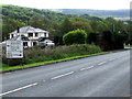
5
West side of the River Dulais road bridge in Crynant
The bridge carries the minor road from Crynant to Ystradgynlais over the River Dulais, a tributary of the River Neath.
Image: © Jaggery
Taken: 16 May 2016
0.09 miles
6
N.A.D.A.C Private Fishing notice near the River Dulais, Crynant
Located on a roadside pole on the north side of the River Dulais,
the N.A.D.A.C (Neath and Dulais Angling Club) notice states
N.A.D.A.C.
PRIVATE FISHING
ROD CARRYING
MEMBERS ONLY
NO DOGS
Image: © Jaggery
Taken: 16 May 2016
0.09 miles
7
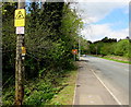
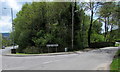
Bus stop sign at the northern end of a river bridge, Crynant
On the left here. http://www.geograph.org.uk/photo/4954871 This side of the road for buses towards the centre of Crynant, and to Neath and Swansea.
Image: © Jaggery
Taken: 16 May 2016
0.10 miles
9
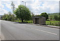
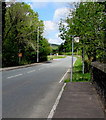
Bus stop and shelter north of Crynant
Alongside the unclassified road between the A4109 and the northern end of Treforgan Road.
Image: © Jaggery
Taken: 16 May 2016
0.10 miles
10
Tre-forgan boundary sign, Crynant
At the northern end of Tre-forgan Road (on the right).
Image: © Jaggery
Taken: 16 May 2016
0.13 miles