IMAGES TAKEN NEAR TO
Cilfrew, NEATH, SA10 8NF
Introduction
This page details the photographs taken nearby to SA10 8NF by members of the Geograph project.
The Geograph project started in 2005 with the aim of publishing, organising and preserving representative images for every square kilometre of Great Britain, Ireland and the Isle of Man.

There are currently over 7.5m images from over14,400 individuals and you can help contribute to the project by visiting https://www.geograph.org.uk
Image Map (Loading...)


Getting Data...Please wait
Leaflet Map data © OpenStreetMap
Images are licensed for reuse under creativecommons.org/licenses/by-sa/2.0
Notes
- Clicking on the map will re-center to the selected point.
- The higher the marker number, the further away the image location is from the centre of the postcode.
Image Listing (9 Images Found)
Images are licensed for reuse under creativecommons.org/licenses/by-sa/2.0
Image
Details
Distance
1
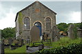
Tabor Chapel (built 1866) near Cilfrew
Image: © Cedwyn Davies
Taken: 14 Jun 2008
0.10 miles
2
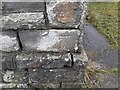
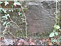
Ordnance Survey Cut Mark
This OS cut mark can be found on the NE angle of the Tabor Chapel. It marks a point 153.055m above mean sea level.
Image: © Adrian Dust
Taken: 6 Jan 2023
0.11 miles
3
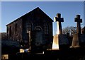
Granite glow
A headstone glows in the late afternoon light at Tabor Chapel, Cilfrew.
Image: © Alan Hughes
Taken: 1 Dec 2017
0.12 miles
4
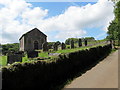
Capel Tabor Chapel, Bryncaws
Tabor, addoldy'r Annibynnwyr a adeiladwyd yn 1866 ar gyfer glowyr a'u teuluoedd a weithiai ym Myllau Glo Torcefn a Marchywel ar dir o eiddo Mr Owen Jones, Brynrhos Cottage gerllaw. Casglwyd £1,800 yn yr ardal at gost y cerrig a'u cludo. Perchnogion y ddwy lofa a dalodd am godi'r adeilad. Er dathlu'r agoriad cynhaliwyd gwasanaethau ar 8ed & 9ed o Ragfyr. Yn 1886 fe'i hailadeiladwyd neu ei hadnewyddu. Cynhelir gwasanaethau yno o hyd maen debyg.
Tabor Independent Welsh Chapel was built in 1866 for the colliers and their families who worked at Torcefn and Marchywel Collieries on land belonging to Mr Owen Jones of nearby Brynrhos Cottage. £18,000 was raised towards the cost and transportation of stone to the site and the mine owners paid for its construction. Opening services were held on 8th & 9th of December. In 1886 the chapel was renovated and possibly rebuilt.
Image: © Alan Richards
Taken: 22 Jul 2016
0.12 miles
6
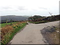
Heol ger Bryn-caws / Road near Bryn-caws
Heol fach yn mynd i gyfeiriad pentre Cil-ffriw. Gwelir ar y dde ffordd fynediad i Ffarm Bryn-caws.
A minor road heading towards the village of Cilfrew. The access road to Bryn-caws Farm (trans. cheese hill) can be seen on the right.
Image: © Alan Richards
Taken: 3 Feb 2020
0.19 miles
7
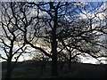
Winter trees
Skeletal trees prepared for winter.
Image: © Alan Hughes
Taken: 1 Dec 2017
0.22 miles
8
Ordnance Survey Cut Mark
This OS cut mark can be found on the east parapet of the bridge. It marks a point 136.127m above mean sea level.
Image: © Adrian Dust
Taken: 6 Jan 2023
0.24 miles
9
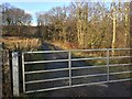
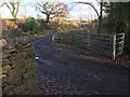
Gated track
The track runs alongside the Nant Rhos valley, past farmland and eventually leads to the Crynant Forest.
Image: © Alan Hughes
Taken: 1 Dec 2017
0.24 miles