IMAGES TAKEN NEAR TO
Aberdulais, NEATH, SA10 8HS
Introduction
This page details the photographs taken nearby to SA10 8HS by members of the Geograph project.
The Geograph project started in 2005 with the aim of publishing, organising and preserving representative images for every square kilometre of Great Britain, Ireland and the Isle of Man.

There are currently over 7.5m images from over14,400 individuals and you can help contribute to the project by visiting https://www.geograph.org.uk
Image Map
Images are licensed for reuse under creativecommons.org/licenses/by-sa/2.0
Notes
- Clicking on the map will re-center to the selected point.
- The higher the marker number, the further away the image location is from the centre of the postcode.
Image Listing (3 Images Found)
Images are licensed for reuse under creativecommons.org/licenses/by-sa/2.0
Image
Details
Distance
1
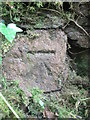
Ordnance Survey Cut Mark
This OS cut mark can be found on the wall to the right of the gate which leads to Fforest Farm. It marks a point 46.470m above mean sea level.
Image: © Adrian Dust
Taken: 14 Jul 2014
0.16 miles
2
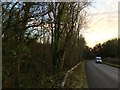
Coed Gawdir
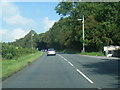
Coed Gawdir alongside the A4109.
Image: © Alan Hughes
Taken: 1 Dec 2017
0.20 miles