IMAGES TAKEN NEAR TO
Riverside, NEATH, SA10 8ES
Introduction
This page details the photographs taken nearby to Riverside, SA10 8ES by members of the Geograph project.
The Geograph project started in 2005 with the aim of publishing, organising and preserving representative images for every square kilometre of Great Britain, Ireland and the Isle of Man.

There are currently over 7.5m images from over14,400 individuals and you can help contribute to the project by visiting https://www.geograph.org.uk
Image Map
Images are licensed for reuse under creativecommons.org/licenses/by-sa/2.0
Notes
- Clicking on the map will re-center to the selected point.
- The higher the marker number, the further away the image location is from the centre of the postcode.
Image Listing (169 Images Found)
Images are licensed for reuse under creativecommons.org/licenses/by-sa/2.0
Image
Details
Distance
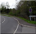
1
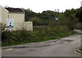
Aberdulais Golf Range & Academy name sign
Facing a side road on the south side of the B4434.
Image: © Jaggery
Taken: 3 May 2016
0.00 miles
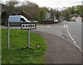
2
Side road south of the B4434, Aberdulais
The name sign at the edge of the building shows Aberdulais Golf Range & Academy.
Image: © Jaggery
Taken: 3 May 2016
0.00 miles
3
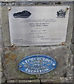
Tonna Road Bridge - 2001 plaque and 1892 plate
Located here. http://www.geograph.org.uk/photo/5251187
The plaque records that Tonna Road Bridge (over the River Neath) was officially opened on December 10th 2001.
The blue metal plate dated 1892 formed part of the original Tonna Bridge, a two-span steel through-girder bridge built in 1892 by E.Finch & Company, Chepstow iron founders.
Image: © Jaggery
Taken: 3 May 2016
0.02 miles
4
Plaque and plate at the western end of Tonna Road Bridge, Tonna
Viewed across the B4434. http://www.geograph.org.uk/photo/5251183 to a closer view.
Image: © Jaggery
Taken: 3 May 2016
0.02 miles
5
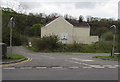
Aberdulais boundary sign facing Tonna
On the corner of Station Road and the B4434.
Image: © Jaggery
Taken: 3 May 2016
0.02 miles
6
B4434 sign, Aberdulais
The sign is on the back of the Aberdulais boundary sign. http://www.geograph.org.uk/photo/5251032
The Tonna boundary sign http://www.geograph.org.uk/photo/5251040 is ahead, on the corner of Station Road.
Image: © Jaggery
Taken: 3 May 2016
0.02 miles
7
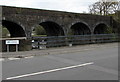
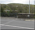
Tonna boundary sign facing Aberdulais
On the corner of Station Road and the B4434. Grade II listed Aberdulais Viaduct http://www.geograph.org.uk/photo/5251017 is in the background.
Image: © Jaggery
Taken: 3 May 2016
0.03 miles
8
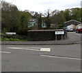
Bilingual Station Road/Heol Gorsaf name sign, Aberdulais
The English/Welsh name sign is near the Tonna boundary sign on the corner of the B4434.
Image: © Jaggery
Taken: 3 May 2016
0.03 miles
9
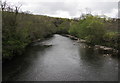
River Neath, Tonna
Viewed from the B4434 Dulais Fach Road in Tonna near Aberdulais.
Image: © Jaggery
Taken: 3 May 2016
0.04 miles
10
Two warning signs alongside Dulais Fach Road, Tonna
The signs facing westbound traffic on the B4434 Dulais Fach Road warn of (a bridge with) 13' 9" headroom 100 yards ahead and minor crossroads.
Image: © Jaggery
Taken: 3 May 2016
0.04 miles