IMAGES TAKEN NEAR TO
Alexander Road, NEATH, SA10 8EF
Introduction
This page details the photographs taken nearby to Alexander Road, SA10 8EF by members of the Geograph project.
The Geograph project started in 2005 with the aim of publishing, organising and preserving representative images for every square kilometre of Great Britain, Ireland and the Isle of Man.

There are currently over 7.5m images from over14,400 individuals and you can help contribute to the project by visiting https://www.geograph.org.uk
Image Map
Images are licensed for reuse under creativecommons.org/licenses/by-sa/2.0
Notes
- Clicking on the map will re-center to the selected point.
- The higher the marker number, the further away the image location is from the centre of the postcode.
Image Listing (26 Images Found)
Images are licensed for reuse under creativecommons.org/licenses/by-sa/2.0
Image
Details
Distance
1
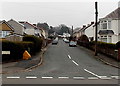
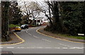
Alexander Road, Rhyddings near Neath
Viewed across the A474. Alexander Road leads to Alexander Crescent.
Image: © Jaggery
Taken: 14 Mar 2014
0.08 miles
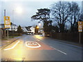
3
30 to 20 along Penywern Road near Bryncoch
The 30mph speed limit reduces to 20mph on the approach to Blaenhonddan Primary School. http://www.geograph.org.uk/photo/3902541
Image: © Jaggery
Taken: 14 Mar 2014
0.13 miles
4
Quarry traffic straight ahead near Bryncoch
The sign giving information for vehicles for Gilfach Quarry is backed up by another sign on the corner of the A474 and Gilfach Road ahead. That sign shows that there is no access to the quarry via Gilfach Road.
Image: © Jaggery
Taken: 14 Mar 2014
0.13 miles
5
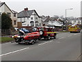
Land Rover and rescue boat on the A474 near Bryncoch
Part of the Mid and West Wales Fire and Rescue Service, the boat and Land Rover
are based at Swansea Central fire station http://www.geograph.org.uk/photo/3738745 as is the fire engine http://www.geograph.org.uk/photo/3944516 ahead.
Image: © Jaggery
Taken: 14 Mar 2014
0.14 miles
6
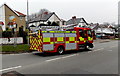
Swansea Central fire engine heads towards Neath
Heading south along the A474 away from Bryncoch, the Mid and West Wales
Fire and Rescue Service fire engine is about 10km from its home base. http://www.geograph.org.uk/photo/3738745
Image: © Jaggery
Taken: 14 Mar 2014
0.14 miles
7
Gilfach Road near Bryncoch
Gilfach Road heads away from the A474. Ahead are Gilfach Farm and Gilfach Wood.
Image: © Jaggery
Taken: 14 Mar 2014
0.14 miles
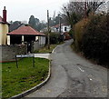
8
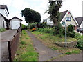
Llwybr Leiros Parc Drive Path
Llwybr cyhoeddus mewn ystad dai.
A public footpath in a housing estate.
Image: © Alan Richards
Taken: 5 Aug 2016
0.15 miles
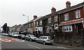
9
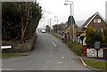
Leiros Parc Drive near Neath
Looking across the A474 Penywern Road along Leiros Parc Drive which leads to several cul-de-sacs.
Image: © Jaggery
Taken: 14 Mar 2014
0.17 miles
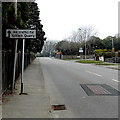
10
Mill Road, Neath
Viewed from Llygad-yr-Haul near the Penywern Road junction.
Image: © Jaggery
Taken: 14 Mar 2014
0.19 miles