IMAGES TAKEN NEAR TO
Dwr Y Felin Road, NEATH, SA10 7RG
Introduction
This page details the photographs taken nearby to Dwr Y Felin Road, SA10 7RG by members of the Geograph project.
The Geograph project started in 2005 with the aim of publishing, organising and preserving representative images for every square kilometre of Great Britain, Ireland and the Isle of Man.

There are currently over 7.5m images from over14,400 individuals and you can help contribute to the project by visiting https://www.geograph.org.uk
Image Map
Images are licensed for reuse under creativecommons.org/licenses/by-sa/2.0
Notes
- Clicking on the map will re-center to the selected point.
- The higher the marker number, the further away the image location is from the centre of the postcode.
Image Listing (22 Images Found)
Images are licensed for reuse under creativecommons.org/licenses/by-sa/2.0
Image
Details
Distance
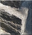
1
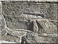
Ordnance Survey Cut Mark
This damaged OS cut mark can be found on the NE buttress of the railway bridge. It marks a point 13.609m above mean sea level. http://www.geograph.org.uk/photo/4385265
Image: © Adrian Dust
Taken: 15 Mar 2015
0.03 miles
2
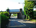
Dwr-Y-Felin Railway Bridge
There is an Ordnance Survey cut mark on the NE buttress. http://www.geograph.org.uk/photo/4385255
Image: © Adrian Dust
Taken: 15 Mar 2015
0.03 miles
3
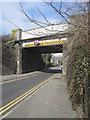
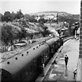
Railway Bridge over Dwr-y-Felin Road.
The bridge carries the main South Wales to London railway between Skewen and Neath.
Image: © Cedwyn Davies
Taken: 15 Jul 2006
0.04 miles
4
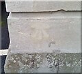
Ordnance Survey Cut Mark
This filled OS cut mark can be found on the north angle of the school. It marked a point 12.692m above mean sea level.
Image: © Adrian Dust
Taken: 23 Oct 2020
0.12 miles
5
Ordnance Survey Rivet
This OS rivet can be found on the Railway Bridge on Neath Abbey Road. It marks a point 10.205m above mean sea level.
Image: © Adrian Dust
Taken: 27 May 2020
0.19 miles
6
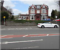
Bronleigh Day Centre, Neath
At 6 Cadoxton Road.
Image: © Jaggery
Taken: 3 May 2016
0.21 miles
7
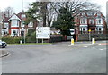
Cadoxton Road junction, Neath
The eastern edge of a mini-roundabout viewed from the northern end of the B4434 at its junction with the A474. Left for Swansea, Merthyr (Tydfil), Neath Abbey and Skewen. Right for Pontardawe, Bryncoch, Cadoxton and Aberdulais.
Image: © Jaggery
Taken: 19 Feb 2011
0.22 miles
8
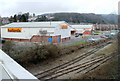
Halfords, Neath
Viewed from the B4434. The Halfords store is in Vale of Neath Retail Park, Cadoxton Road. Behind it is a Carpet Right store.
Image: © Jaggery
Taken: 19 Feb 2011
0.22 miles
9
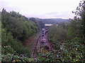
Neath Riverside station
In the years before closure, just one daily train departed from Neath Riverside to Brecon. The South Wales main line passes over the bridge top right. The signalbox remains to this day, controlling freight trains from Onllwyn in the Dulais valley.
Image: © Flying Stag
Taken: Unknown
0.22 miles
10
Former Neath Riverside Railway Station & Signalbox
Viewed from footbridge linking Neath college area to Neath town centre. The train is viewed leaving the line(s) from Onllwyn and Cwmgwrach.
Image: © Steven Morgan
Taken: Unknown
0.22 miles