IMAGES TAKEN NEAR TO
Llys Iris, NEATH, SA10 7QW
Introduction
This page details the photographs taken nearby to Llys Iris, SA10 7QW by members of the Geograph project.
The Geograph project started in 2005 with the aim of publishing, organising and preserving representative images for every square kilometre of Great Britain, Ireland and the Isle of Man.

There are currently over 7.5m images from over14,400 individuals and you can help contribute to the project by visiting https://www.geograph.org.uk
Image Map (Loading...)


Getting Data...Please wait
Leaflet Map data © OpenStreetMap
Images are licensed for reuse under creativecommons.org/licenses/by-sa/2.0
Notes
- Clicking on the map will re-center to the selected point.
- The higher the marker number, the further away the image location is from the centre of the postcode.
Image Listing (4 Images Found)
Images are licensed for reuse under creativecommons.org/licenses/by-sa/2.0
Image
Details
Distance
1
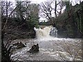
Falls on the Clydach
The falls on the river Clydach in full spate, the power that once drove the wheels of industry going to waste. The pool into which it falls was once known to older residents of the area as Pwll Ddu - (Black Pool).
Image: © Robert Davies
Taken: 15 Jan 2008
0.18 miles
2
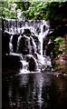
Falls on the River Clydach at Longford
These falls were formerly the site of a large waterwheel used to power the old Neath Abbey Ironworks that were situated below the falls.
Image: © Dai Bevan
Taken: Unknown
0.18 miles
4
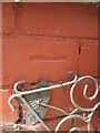
Ordnance Survey Cut Mark
This OS cut mark can be found on No63 Longford Road. It marks a point 38.457m above mean sea level.
Image: © Adrian Dust
Taken: 13 Jul 2014
0.24 miles