IMAGES TAKEN NEAR TO
Cadoxton Road, NEATH, SA10 7AB
Introduction
This page details the photographs taken nearby to Cadoxton Road, SA10 7AB by members of the Geograph project.
The Geograph project started in 2005 with the aim of publishing, organising and preserving representative images for every square kilometre of Great Britain, Ireland and the Isle of Man.

There are currently over 7.5m images from over14,400 individuals and you can help contribute to the project by visiting https://www.geograph.org.uk
Image Map
Images are licensed for reuse under creativecommons.org/licenses/by-sa/2.0
Notes
- Clicking on the map will re-center to the selected point.
- The higher the marker number, the further away the image location is from the centre of the postcode.
Image Listing (85 Images Found)
Images are licensed for reuse under creativecommons.org/licenses/by-sa/2.0
Image
Details
Distance
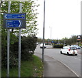
1
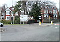
Cadoxton Road junction, Neath
The eastern edge of a mini-roundabout viewed from the northern end of the B4434 at its junction with the A474. Left for Swansea, Merthyr (Tydfil), Neath Abbey and Skewen. Right for Pontardawe, Bryncoch, Cadoxton and Aberdulais.
Image: © Jaggery
Taken: 19 Feb 2011
0.03 miles
2
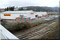
Halfords, Neath
Viewed from the B4434. The Halfords store is in Vale of Neath Retail Park, Cadoxton Road. Behind it is a Carpet Right store.
Image: © Jaggery
Taken: 19 Feb 2011
0.03 miles
3
Bronleigh Day Centre, Neath
At 6 Cadoxton Road.
Image: © Jaggery
Taken: 3 May 2016
0.03 miles
4
Ordnance Survey Rivet
This OS rivet can be found on the Railway Bridge on Neath Abbey Road. It marks a point 10.205m above mean sea level.
Image: © Adrian Dust
Taken: 27 May 2020
0.05 miles
5
Bilingual cycle route direction signs, Cadoxton Road, Neath
The English/Welsh signs show Neath/Castell Nedd and Skewen/Sgiwen.
Image: © Jaggery
Taken: 3 May 2016
0.05 miles
6
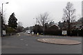
Road to Pontardawe from Neath
Signs showing Pontardawe A474 point along both sides of the road.
Another two signs pointing the same way show Bryncoch, Rhos and Alltwen.
Image: © Jaggery
Taken: 14 Mar 2014
0.05 miles
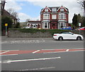
7
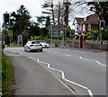
Pelican crossing, Cadoxton Road, Neath
Across the A474 Cadoxton Road. Chambers Dictionary states that pelican
in this context is adapted from "pedestrian light controlled crossing".
Image: © Jaggery
Taken: 3 May 2016
0.06 miles
8
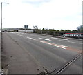
B4434 bridge, Neath
Viewed from the northern end of the bridge carrying the B4434 over railway lines, the A465, the Tennant Canal and the River Neath. Ahead for the town centre.
Image: © Jaggery
Taken: 3 May 2016
0.06 miles
9
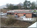
Burger King, Neath
Burger King, Cadoxton Road, viewed from the B4434.
Image: © Jaggery
Taken: 19 Feb 2011
0.06 miles
10
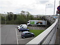
Parking area in the Vale of Neath Retail Park
Opposite Halfords. http://www.geograph.org.uk/photo/5128453
Image: © Jaggery
Taken: 3 May 2016
0.06 miles