IMAGES TAKEN NEAR TO
Ballards Court, NEATH, SA10 6PN
Introduction
This page details the photographs taken nearby to Ballards Court, SA10 6PN by members of the Geograph project.
The Geograph project started in 2005 with the aim of publishing, organising and preserving representative images for every square kilometre of Great Britain, Ireland and the Isle of Man.

There are currently over 7.5m images from over14,400 individuals and you can help contribute to the project by visiting https://www.geograph.org.uk
Image Map (Loading...)


Getting Data...Please wait
Leaflet Map data © OpenStreetMap
Images are licensed for reuse under creativecommons.org/licenses/by-sa/2.0
Notes
- Clicking on the map will re-center to the selected point.
- The higher the marker number, the further away the image location is from the centre of the postcode.
Image Listing (12 Images Found)
Images are licensed for reuse under creativecommons.org/licenses/by-sa/2.0
Image
Details
Distance
1
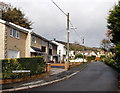
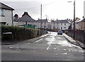
Sunnyland Crescent, Skewen
A cul-de-sac on the north side of Dynevor Road.
Image: © Jaggery
Taken: 5 Nov 2013
0.13 miles
2
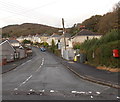
Cwrt-y-Clafdy, Skewen
Cwrt-y-Clafdy climbs away from Dynevor Road.
Image: © Jaggery
Taken: 5 Nov 2013
0.14 miles
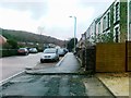
4
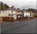
The Highlands, Skewen
Houses at the southern end of a street named The Highlands, viewed from Dynevor Road.
Image: © Jaggery
Taken: 5 Nov 2013
0.18 miles
5
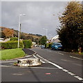
Circular stone base at the junction of The Highlands and Dynevor Road, Skewen
The hole inside the base is rectangular, but what used to be in the base is unknown to this contributor.
Image: © Jaggery
Taken: 5 Nov 2013
0.19 miles
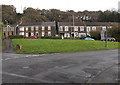
6
Semi-detached houses in Dynevor Road, Skewen
A long row of houses http://www.geograph.org.uk/photo/3733169 is behind the camera. Semi-detached houses are ahead.
Image: © Jaggery
Taken: 5 Nov 2013
0.20 miles
7
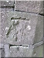
Ordnance Survey Cut Mark
This damaged OS cut mark can be found on the wall at the junction of the track and Drumau Road. It marks a point 84.686m above mean sea level.
Image: © Adrian Dust
Taken: 20 Apr 2014
0.21 miles
8
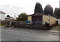
Community of Christ church, Skewen
Located on the south side of Dynevor Road, near the Jubilee Crescent junction. The Community of Christ was known until 2001 as the Reorganized Church of Jesus Christ of Latter Day Saints.
Image: © Jaggery
Taken: 5 Nov 2013
0.21 miles
9
Jubilee Crescent, Skewen
Viewed across Dynevor Road. Jubilee Crescent is a cul-de-sac ending on the north side of railway lines.
Image: © Jaggery
Taken: 5 Nov 2013
0.22 miles
10
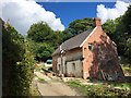
Derelict house
Derelict house being restored.
Image: © Alan Hughes
Taken: 10 Aug 2018
0.22 miles