IMAGES TAKEN NEAR TO
Drummau Road, NEATH, SA10 6NY
Introduction
This page details the photographs taken nearby to Drummau Road, SA10 6NY by members of the Geograph project.
The Geograph project started in 2005 with the aim of publishing, organising and preserving representative images for every square kilometre of Great Britain, Ireland and the Isle of Man.

There are currently over 7.5m images from over14,400 individuals and you can help contribute to the project by visiting https://www.geograph.org.uk
Image Map
Images are licensed for reuse under creativecommons.org/licenses/by-sa/2.0
Notes
- Clicking on the map will re-center to the selected point.
- The higher the marker number, the further away the image location is from the centre of the postcode.
Image Listing (70 Images Found)
Images are licensed for reuse under creativecommons.org/licenses/by-sa/2.0
Image
Details
Distance
1
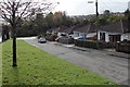
Drummau Road bungalows, Skewen
The bungalows are alongside an access road on the west side of Drummau Road (out of shot on the left).
Image: © Jaggery
Taken: 5 Nov 2013
0.04 miles
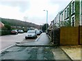
2
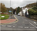
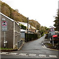
Drummau Road, Skewen
Viewed from New Road looking towards a railway bridge. http://www.geograph.org.uk/photo/3733227
The blue sign on a lamppost shows Unsuitable for heavy goods vehicles.
Image: © Jaggery
Taken: 5 Nov 2013
0.05 miles
3
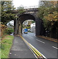
Drummau Road railway bridge, Skewen
The bridge carries the railway over Drummau Road about 750 metres east of Skewen railway station.
Image: © Jaggery
Taken: 5 Nov 2013
0.05 miles
4
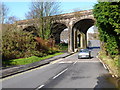
Railway viaduct at Drummau Road, Skewen
Image: © Kevin Trahar
Taken: 30 Nov 2009
0.05 miles
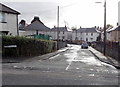
5
Hill Road, Skewen
Viewed across Drummau Road.
Image: © Jaggery
Taken: 5 Nov 2013
0.05 miles
6
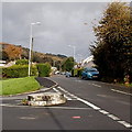
Circular stone base at the junction of The Highlands and Dynevor Road, Skewen
The hole inside the base is rectangular, but what used to be in the base is unknown to this contributor.
Image: © Jaggery
Taken: 5 Nov 2013
0.05 miles
7
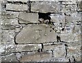
Ordnance Survey Cut Mark
This OS cut mark can be found on the wall of No8 Hill Road. It marks a point 33.961m above mean sea level.
Image: © Adrian Dust
Taken: 13 Oct 2020
0.06 miles
8
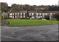
The Highlands, Skewen
Houses at the southern end of a street named The Highlands, viewed from Dynevor Road.
Image: © Jaggery
Taken: 5 Nov 2013
0.06 miles
10
Jubilee Crescent, Skewen
Viewed across Dynevor Road. Jubilee Crescent is a cul-de-sac ending on the north side of railway lines.
Image: © Jaggery
Taken: 5 Nov 2013
0.09 miles