IMAGES TAKEN NEAR TO
Catcliffe Road, SHEFFIELD, S9 5JJ
Introduction
This page details the photographs taken nearby to Catcliffe Road, S9 5JJ by members of the Geograph project.
The Geograph project started in 2005 with the aim of publishing, organising and preserving representative images for every square kilometre of Great Britain, Ireland and the Isle of Man.

There are currently over 7.5m images from over14,400 individuals and you can help contribute to the project by visiting https://www.geograph.org.uk
Image Map
Images are licensed for reuse under creativecommons.org/licenses/by-sa/2.0
Notes
- Clicking on the map will re-center to the selected point.
- The higher the marker number, the further away the image location is from the centre of the postcode.
Image Listing (64 Images Found)
Images are licensed for reuse under creativecommons.org/licenses/by-sa/2.0
Image
Details
Distance
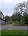
1
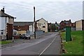
Catcliffe Road, Darnall
Most of the buildings on this road have been demolished. In the distance can be seen part of the Green Social Club. Image
Image: © P L Chadwick
Taken: 12 Apr 2009
0.01 miles
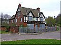
2
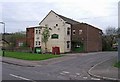
The Green Social Club, Darnall
Originally a working men's club, today this is The Green Social Club. Unlike a lot of the pubs in this area of Sheffield, this club is still open.
Image: © P L Chadwick
Taken: 12 Apr 2009
0.03 miles
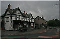
3
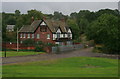
The Halfway House
I think this used to be a Wards House and may have been called something else in former days. It was for a long time invisible from the main road as the grassed area in the foreground used to be buildings.
Image: © David Lally
Taken: 6 Sep 2008
0.03 miles
4
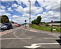
Greenland Road
The A6102 at its junction with Senior Road.
Image: © Gerald England
Taken: 10 May 2018
0.04 miles
5
Infield Lane, Darnall
This lane goes past allotments and a golf course. On the left of the picture can be seen the closed Halfway House public house. Image
Image: © P L Chadwick
Taken: 12 Apr 2009
0.05 miles
6
Halfway House, 80 Britannia Road, Darnall
It's not clear what this was halfway to, but it's a very depressing sight. The owners seem to have lost all interest and as long ago as 2006 the City Council had to put up fencing to stop a serious fly-tipping problem. At one time it was a very popular pub with a beer garden and crown green bowling. Today, looking from the outside, you can see huge holes in the roof, so the inside must be in a very poor state. On a Sheffield forum someone says it is about to be pulled down which, given the number of pubs in Darnall which are closed but in better condition, does seem very plausible. What a great pity.
Image: © P L Chadwick
Taken: 12 Apr 2009
0.05 miles
8
Former Pub, Main Road
This one has been closed for a quite some time, I think it used to be called The Crown, but could very well be wrong. Now a Learning Centre.
Update September 2018: It was in fact the Rose & Crown, so my memory was not entirely inaccurate. More details can be found here: http://www.closedpubs.co.uk/yorkshire/sheffield_s9_rosecrown.html and here: http://www.geograph.org.uk/photo/5909012
Image: © David Lally
Taken: 6 Sep 2008
0.06 miles

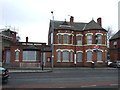
10

Darnall Post Office
This former pub Image, the Rose and Crown which closed in 2003 http://www.closedpubs.co.uk/yorkshire/sheffield_s9_rosecrown.html is home to Darnall Forum http://www.dfenterprise.org.uk/ The forum has been running the Post Office since 2010 https://www.yorkshirepost.co.uk/news/community-to-reopen-city-post-office-in-groundbreaking-move-1-2586094 but they have now sold it on to a local buyer http://darnallforum.blogspot.com/p/darnall-post-office.html
Image: © Gerald England
Taken: 10 May 2018
0.07 miles